You are here: Home > Network List > CI - Caltech Regional Seismic Network Stations List
> Station MPP McPhearson Peak > Earthquake Result Viewer
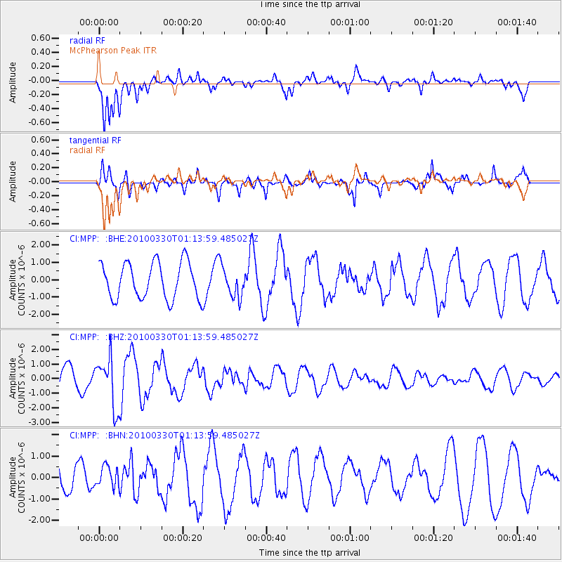
MPP McPhearson Peak - Earthquake Result Viewer
*The percent match for this event was below the threshold and hence no stack was calculated.
| Earthquake location: |
Eastern Sea Of Japan |
| Earthquake latitude/longitude: |
43.3/138.4 |
| Earthquake time(UTC): |
2010/03/30 (089) 01:02:53 GMT |
| Earthquake Depth: |
21 km |
| Earthquake Magnitude: |
6.1 MB, 5.3 MS, 5.7 MW, 5.6 MW |
| Earthquake Catalog/Contributor: |
WHDF/NEIC |
|
| Network: |
CI Caltech Regional Seismic Network |
| Station: |
MPP McPhearson Peak |
| Lat/Lon: |
34.89 N/119.81 W |
| Elevation: |
1739 m |
|
| Distance: |
74.6 deg |
| Az: |
56.597 deg |
| Baz: |
312.149 deg |
| Ray Param: |
$rayparam |
*The percent match for this event was below the threshold and hence was not used in the summary stack. |
|
| Radial Match: |
57.10116 % |
| Radial Bump: |
400 |
| Transverse Match: |
81.24725 % |
| Transverse Bump: |
353 |
| SOD ConfigId: |
312771 |
| Insert Time: |
2010-06-28 17:17:06.296 +0000 |
| GWidth: |
2.5 |
| Max Bumps: |
400 |
| Tol: |
0.001 |
|
Signal To Noise
| Channel | StoN | STA | LTA |
| CI:MPP: :BHZ:20100330T01:13:59.485027Z | 2.3780963 | 1.7538339E-6 | 7.374949E-7 |
| CI:MPP: :BHN:20100330T01:13:59.485027Z | 0.39307266 | 4.954618E-7 | 1.260484E-6 |
| CI:MPP: :BHE:20100330T01:13:59.485027Z | 0.8048564 | 8.3994473E-7 | 1.0435958E-6 |
| Arrivals |
| Ps | |
| PpPs | |
| PsPs/PpSs | |


