You are here: Home > Network List > CI - Caltech Regional Seismic Network Stations List
> Station TUQ Turquiose Mountain, Baker, CA, USA > Earthquake Result Viewer
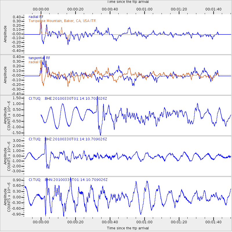
TUQ Turquiose Mountain, Baker, CA, USA - Earthquake Result Viewer
*The percent match for this event was below the threshold and hence no stack was calculated.
| Earthquake location: |
Eastern Sea Of Japan |
| Earthquake latitude/longitude: |
43.3/138.4 |
| Earthquake time(UTC): |
2010/03/30 (089) 01:02:53 GMT |
| Earthquake Depth: |
21 km |
| Earthquake Magnitude: |
6.1 MB, 5.3 MS, 5.7 MW, 5.6 MW |
| Earthquake Catalog/Contributor: |
WHDF/NEIC |
|
| Network: |
CI Caltech Regional Seismic Network |
| Station: |
TUQ Turquiose Mountain, Baker, CA, USA |
| Lat/Lon: |
35.44 N/115.92 W |
| Elevation: |
1350 m |
|
| Distance: |
76.5 deg |
| Az: |
53.943 deg |
| Baz: |
313.717 deg |
| Ray Param: |
$rayparam |
*The percent match for this event was below the threshold and hence was not used in the summary stack. |
|
| Radial Match: |
56.60583 % |
| Radial Bump: |
400 |
| Transverse Match: |
49.547306 % |
| Transverse Bump: |
380 |
| SOD ConfigId: |
312771 |
| Insert Time: |
2010-06-28 17:17:18.765 +0000 |
| GWidth: |
2.5 |
| Max Bumps: |
400 |
| Tol: |
0.001 |
|
Signal To Noise
| Channel | StoN | STA | LTA |
| CI:TUQ: :BHZ:20100330T01:14:10.709026Z | 4.645466 | 1.5442588E-6 | 3.3242281E-7 |
| CI:TUQ: :BHN:20100330T01:14:10.709026Z | 0.81621474 | 3.877202E-7 | 4.750223E-7 |
| CI:TUQ: :BHE:20100330T01:14:10.709026Z | 1.427835 | 8.4700093E-7 | 5.9320644E-7 |
| Arrivals |
| Ps | |
| PpPs | |
| PsPs/PpSs | |


