You are here: Home > Network List > TX - Texas Seismological Network Stations List
> Station WTFS Witchita Falls > Earthquake Result Viewer
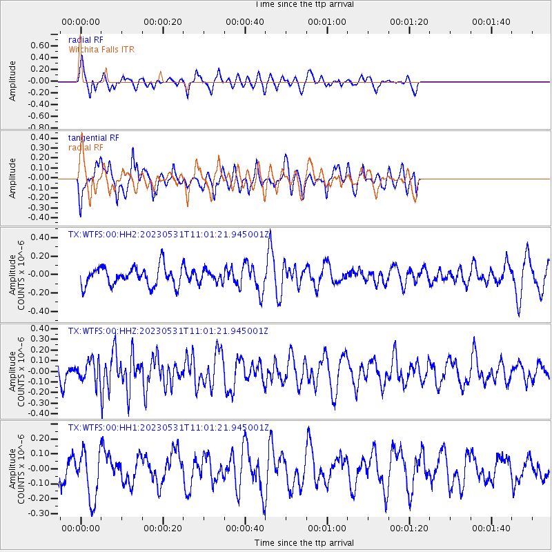
WTFS Witchita Falls - Earthquake Result Viewer
*The percent match for this event was below the threshold and hence no stack was calculated.
| Earthquake location: |
Galapagos Islands Region |
| Earthquake latitude/longitude: |
1.4/-90.7 |
| Earthquake time(UTC): |
2023/05/31 (151) 10:55:17 GMT |
| Earthquake Depth: |
10 km |
| Earthquake Magnitude: |
5.5 Mww |
| Earthquake Catalog/Contributor: |
NEIC PDE/us |
|
| Network: |
TX Texas Seismological Network |
| Station: |
WTFS Witchita Falls |
| Lat/Lon: |
33.77 N/98.46 W |
| Elevation: |
277 m |
|
| Distance: |
33.0 deg |
| Az: |
348.055 deg |
| Baz: |
165.619 deg |
| Ray Param: |
$rayparam |
*The percent match for this event was below the threshold and hence was not used in the summary stack. |
|
| Radial Match: |
51.30698 % |
| Radial Bump: |
332 |
| Transverse Match: |
65.424576 % |
| Transverse Bump: |
400 |
| SOD ConfigId: |
30536071 |
| Insert Time: |
2023-06-14 11:15:52.818 +0000 |
| GWidth: |
2.5 |
| Max Bumps: |
400 |
| Tol: |
0.001 |
|
Signal To Noise
| Channel | StoN | STA | LTA |
| TX:WTFS:00:HHZ:20230531T11:01:21.945001Z | 1.1787401 | 9.799162E-8 | 8.31325E-8 |
| TX:WTFS:00:HH1:20230531T11:01:21.945001Z | 1.6640687 | 1.6835969E-7 | 1.0117352E-7 |
| TX:WTFS:00:HH2:20230531T11:01:21.945001Z | 0.64300674 | 6.528276E-8 | 1.0152733E-7 |
| Arrivals |
| Ps | |
| PpPs | |
| PsPs/PpSs | |


