You are here: Home > Network List > UU - University of Utah Regional Network Stations List
> Station CCUT Cedar City, UT, USA > Earthquake Result Viewer
CCUT Cedar City, UT, USA - Earthquake Result Viewer
| Earthquake location: |
Northern Chile |
| Earthquake latitude/longitude: |
-19.6/-69.3 |
| Earthquake time(UTC): |
2018/11/01 (305) 22:19:51 GMT |
| Earthquake Depth: |
102 km |
| Earthquake Magnitude: |
6.2 Mww |
| Earthquake Catalog/Contributor: |
NEIC PDE/us |
|
| Network: |
UU University of Utah Regional Network |
| Station: |
CCUT Cedar City, UT, USA |
| Lat/Lon: |
37.55 N/113.36 W |
| Elevation: |
2127 m |
|
| Distance: |
70.4 deg |
| Az: |
324.058 deg |
| Baz: |
135.869 deg |
| Ray Param: |
0.05478075 |
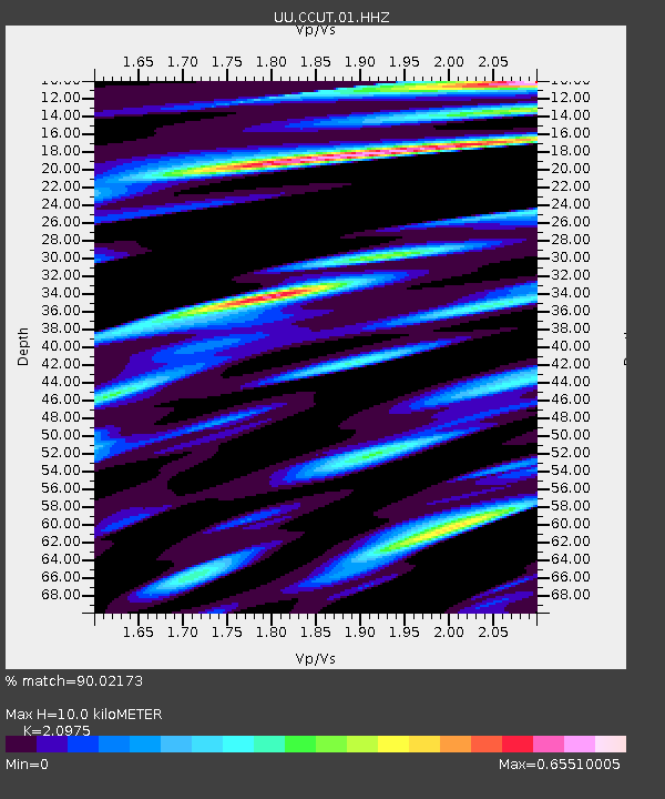
| Estimated Moho Depth: |
10.0 km |
| Estimated Crust Vp/Vs: |
2.10 |
| Assumed Crust Vp: |
6.194 km/s |
| Estimated Crust Vs: |
2.953 km/s |
| Estimated Crust Poisson's Ratio: |
0.35 |
|
| Radial Match: |
90.02173 % |
| Radial Bump: |
319 |
| Transverse Match: |
88.08736 % |
| Transverse Bump: |
400 |
| SOD ConfigId: |
3131071 |
| Insert Time: |
2018-11-15 22:31:06.738 +0000 |
| GWidth: |
2.5 |
| Max Bumps: |
400 |
| Tol: |
0.001 |
|

Signal To Noise
| Channel | StoN | STA | LTA |
| UU:CCUT:01:HHZ:20181101T22:30:23.474998Z | 22.531532 | 3.1332531E-6 | 1.390608E-7 |
| UU:CCUT:01:HHN:20181101T22:30:23.474998Z | 3.2327552 | 6.093995E-7 | 1.8850777E-7 |
| UU:CCUT:01:HHE:20181101T22:30:23.474998Z | 8.330644 | 1.0638631E-6 | 1.2770478E-7 |
| Arrivals |
| Ps | 1.8 SECOND |
| PpPs | 4.9 SECOND |
| PsPs/PpSs | 6.7 SECOND |


