You are here: Home > Network List > UU - University of Utah Regional Network Stations List
> Station FORU South Mineral Mountains, UT, USA > Earthquake Result Viewer
FORU South Mineral Mountains, UT, USA - Earthquake Result Viewer

| Earthquake location: |
Northern Chile |
| Earthquake latitude/longitude: |
-19.6/-69.3 |
| Earthquake time(UTC): |
2018/11/01 (305) 22:19:51 GMT |
| Earthquake Depth: |
102 km |
| Earthquake Magnitude: |
6.2 Mww |
| Earthquake Catalog/Contributor: |
NEIC PDE/us |
|
| Network: |
UU University of Utah Regional Network |
| Station: |
FORU South Mineral Mountains, UT, USA |
| Lat/Lon: |
38.46 N/112.86 W |
| Elevation: |
1840 m |
|
| Distance: |
70.7 deg |
| Az: |
325.027 deg |
| Baz: |
136.499 deg |
| Ray Param: |
0.05453015 |
| Estimated Moho Depth: |
30.5 km |
| Estimated Crust Vp/Vs: |
2.06 |
| Assumed Crust Vp: |
6.276 km/s |
| Estimated Crust Vs: |
3.043 km/s |
| Estimated Crust Poisson's Ratio: |
0.35 |
|
| Radial Match: |
82.64298 % |
| Radial Bump: |
357 |
| Transverse Match: |
68.984314 % |
| Transverse Bump: |
317 |
| SOD ConfigId: |
3131071 |
| Insert Time: |
2018-11-15 22:31:20.465 +0000 |
| GWidth: |
2.5 |
| Max Bumps: |
400 |
| Tol: |
0.001 |
|
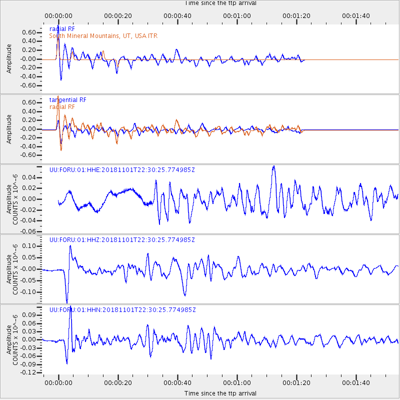
Signal To Noise
| Channel | StoN | STA | LTA |
| UU:FORU:01:HHZ:20181101T22:30:25.774985Z | 12.288432 | 6.17388E-8 | 5.0241398E-9 |
| UU:FORU:01:HHN:20181101T22:30:25.774985Z | 6.037318 | 4.7686935E-8 | 7.898695E-9 |
| UU:FORU:01:HHE:20181101T22:30:25.774985Z | 1.3816901 | 1.806204E-8 | 1.3072425E-8 |
| Arrivals |
| Ps | 5.3 SECOND |
| PpPs | 14 SECOND |
| PsPs/PpSs | 20 SECOND |


