You are here: Home > Network List > KR - Kyrgyz Digital Network Stations List
> Station SALK Salom-Alik, Kyrgyzstan > Earthquake Result Viewer
SALK Salom-Alik, Kyrgyzstan - Earthquake Result Viewer
| Earthquake location: |
Off East Coast Of Kamchatka |
| Earthquake latitude/longitude: |
55.3/163.1 |
| Earthquake time(UTC): |
2023/05/31 (151) 14:01:45 GMT |
| Earthquake Depth: |
10 km |
| Earthquake Magnitude: |
5.5 Mww |
| Earthquake Catalog/Contributor: |
NEIC PDE/us |
|
| Network: |
KR Kyrgyz Digital Network |
| Station: |
SALK Salom-Alik, Kyrgyzstan |
| Lat/Lon: |
40.88 N/73.82 E |
| Elevation: |
1672 m |
|
| Distance: |
57.3 deg |
| Az: |
295.696 deg |
| Baz: |
42.789 deg |
| Ray Param: |
0.063595235 |
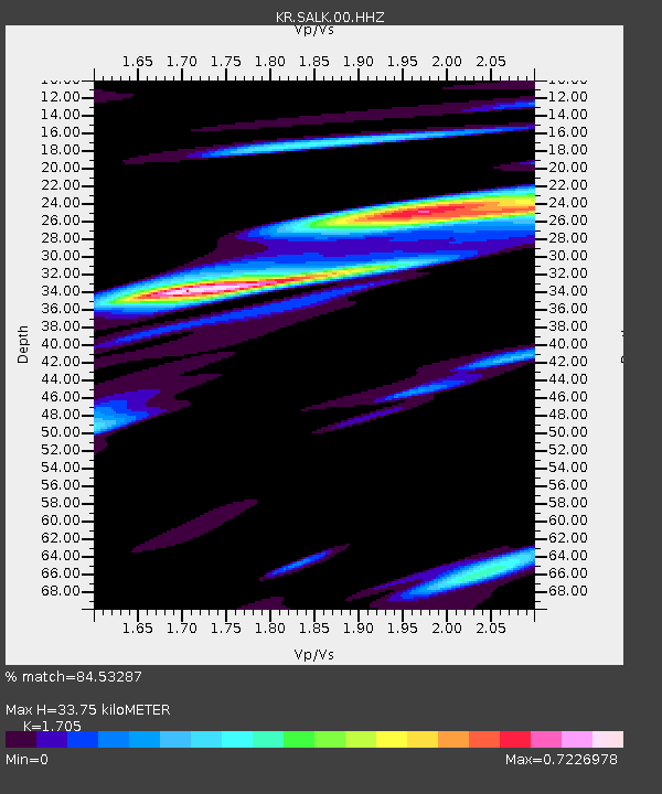
| Estimated Moho Depth: |
33.75 km |
| Estimated Crust Vp/Vs: |
1.71 |
| Assumed Crust Vp: |
6.306 km/s |
| Estimated Crust Vs: |
3.699 km/s |
| Estimated Crust Poisson's Ratio: |
0.24 |
|
| Radial Match: |
84.53287 % |
| Radial Bump: |
400 |
| Transverse Match: |
71.80091 % |
| Transverse Bump: |
400 |
| SOD ConfigId: |
30536071 |
| Insert Time: |
2023-06-14 14:14:51.917 +0000 |
| GWidth: |
2.5 |
| Max Bumps: |
400 |
| Tol: |
0.001 |
|

Signal To Noise
| Channel | StoN | STA | LTA |
| KR:SALK:00:HHZ:20230531T14:11:02.219983Z | 4.258836 | 1.6278638E-7 | 3.822321E-8 |
| KR:SALK:00:HHN:20230531T14:11:02.219983Z | 1.6747254 | 7.458715E-8 | 4.4536943E-8 |
| KR:SALK:00:HHE:20230531T14:11:02.219983Z | 2.5185583 | 1.0540431E-7 | 4.1851052E-8 |
| Arrivals |
| Ps | 4.0 SECOND |
| PpPs | 14 SECOND |
| PsPs/PpSs | 18 SECOND |


