You are here: Home > Network List > US - United States National Seismic Network Stations List
> Station DGMT Dagmar, Montana, USA > Earthquake Result Viewer
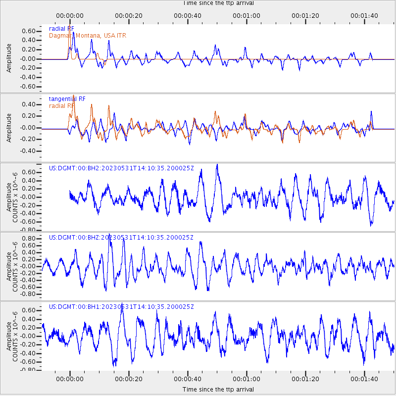
DGMT Dagmar, Montana, USA - Earthquake Result Viewer
*The percent match for this event was below the threshold and hence no stack was calculated.
| Earthquake location: |
Off East Coast Of Kamchatka |
| Earthquake latitude/longitude: |
55.3/163.1 |
| Earthquake time(UTC): |
2023/05/31 (151) 14:01:45 GMT |
| Earthquake Depth: |
10 km |
| Earthquake Magnitude: |
5.5 Mww |
| Earthquake Catalog/Contributor: |
NEIC PDE/us |
|
| Network: |
US United States National Seismic Network |
| Station: |
DGMT Dagmar, Montana, USA |
| Lat/Lon: |
48.47 N/104.20 W |
| Elevation: |
646 m |
|
| Distance: |
53.5 deg |
| Az: |
55.762 deg |
| Baz: |
314.762 deg |
| Ray Param: |
$rayparam |
*The percent match for this event was below the threshold and hence was not used in the summary stack. |
|
| Radial Match: |
71.970665 % |
| Radial Bump: |
328 |
| Transverse Match: |
55.613056 % |
| Transverse Bump: |
400 |
| SOD ConfigId: |
30536071 |
| Insert Time: |
2023-06-14 14:26:31.519 +0000 |
| GWidth: |
2.5 |
| Max Bumps: |
400 |
| Tol: |
0.001 |
|
Signal To Noise
| Channel | StoN | STA | LTA |
| US:DGMT:00:BHZ:20230531T14:10:35.200025Z | 2.321729 | 2.8777575E-7 | 1.239489E-7 |
| US:DGMT:00:BH1:20230531T14:10:35.200025Z | 0.8747049 | 1.6163995E-7 | 1.8479369E-7 |
| US:DGMT:00:BH2:20230531T14:10:35.200025Z | 1.7546736 | 2.6660916E-7 | 1.5194232E-7 |
| Arrivals |
| Ps | |
| PpPs | |
| PsPs/PpSs | |


