You are here: Home > Network List > US - United States National Seismic Network Stations List
> Station MSO Missoula, Montana, USA > Earthquake Result Viewer
MSO Missoula, Montana, USA - Earthquake Result Viewer
*The percent match for this event was below the threshold and hence no stack was calculated.
| Earthquake location: |
Off East Coast Of Kamchatka |
| Earthquake latitude/longitude: |
55.3/163.1 |
| Earthquake time(UTC): |
2023/05/31 (151) 14:01:45 GMT |
| Earthquake Depth: |
10 km |
| Earthquake Magnitude: |
5.5 Mww |
| Earthquake Catalog/Contributor: |
NEIC PDE/us |
|
| Network: |
US United States National Seismic Network |
| Station: |
MSO Missoula, Montana, USA |
| Lat/Lon: |
46.83 N/113.94 W |
| Elevation: |
1264 m |
|
| Distance: |
49.9 deg |
| Az: |
63.046 deg |
| Baz: |
312.095 deg |
| Ray Param: |
$rayparam |
*The percent match for this event was below the threshold and hence was not used in the summary stack. |
|
| Radial Match: |
63.65432 % |
| Radial Bump: |
400 |
| Transverse Match: |
82.18378 % |
| Transverse Bump: |
400 |
| SOD ConfigId: |
30536071 |
| Insert Time: |
2023-06-14 14:26:54.977 +0000 |
| GWidth: |
2.5 |
| Max Bumps: |
400 |
| Tol: |
0.001 |
|
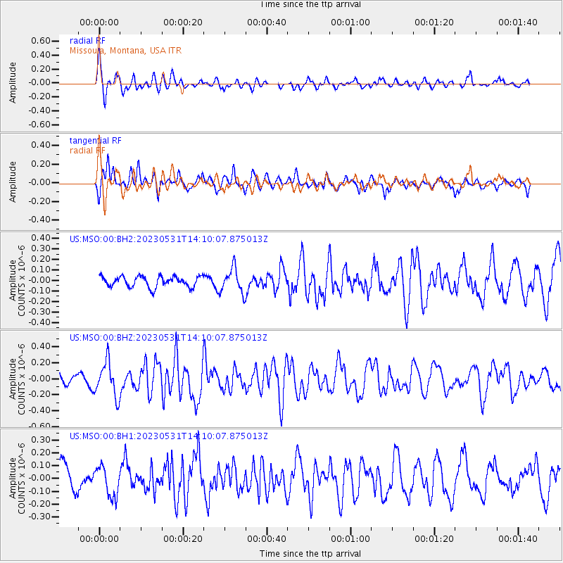
Signal To Noise
| Channel | StoN | STA | LTA |
| US:MSO:00:BHZ:20230531T14:10:07.875013Z | 2.8031478 | 2.2141923E-7 | 7.8989494E-8 |
| US:MSO:00:BH1:20230531T14:10:07.875013Z | 1.2014346 | 1.1828122E-7 | 9.844998E-8 |
| US:MSO:00:BH2:20230531T14:10:07.875013Z | 2.3419888 | 1.18376065E-7 | 5.05451E-8 |
| Arrivals |
| Ps | |
| PpPs | |
| PsPs/PpSs | |


