You are here: Home > Network List > TA - USArray Transportable Network (new EarthScope stations) Stations List
> Station O22A Kremmling, CO, USA > Earthquake Result Viewer
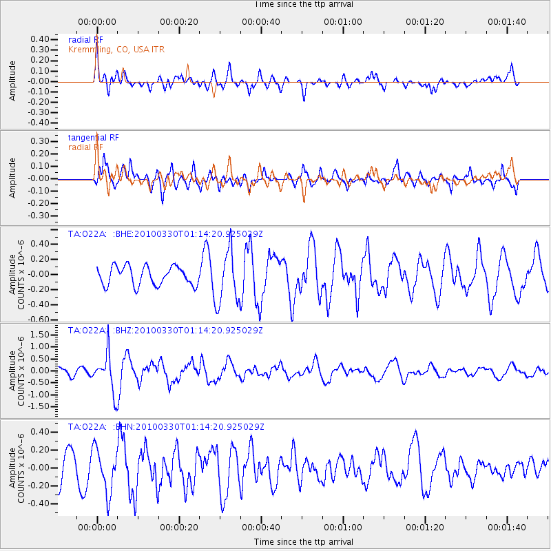
O22A Kremmling, CO, USA - Earthquake Result Viewer
*The percent match for this event was below the threshold and hence no stack was calculated.
| Earthquake location: |
Eastern Sea Of Japan |
| Earthquake latitude/longitude: |
43.3/138.4 |
| Earthquake time(UTC): |
2010/03/30 (089) 01:02:53 GMT |
| Earthquake Depth: |
21 km |
| Earthquake Magnitude: |
6.1 MB, 5.3 MS, 5.7 MW, 5.6 MW |
| Earthquake Catalog/Contributor: |
WHDF/NEIC |
|
| Network: |
TA USArray Transportable Network (new EarthScope stations) |
| Station: |
O22A Kremmling, CO, USA |
| Lat/Lon: |
40.16 N/106.55 W |
| Elevation: |
2747 m |
|
| Distance: |
78.4 deg |
| Az: |
45.132 deg |
| Baz: |
317.532 deg |
| Ray Param: |
$rayparam |
*The percent match for this event was below the threshold and hence was not used in the summary stack. |
|
| Radial Match: |
42.386234 % |
| Radial Bump: |
400 |
| Transverse Match: |
61.522243 % |
| Transverse Bump: |
400 |
| SOD ConfigId: |
312771 |
| Insert Time: |
2010-06-28 17:29:34.211 +0000 |
| GWidth: |
2.5 |
| Max Bumps: |
400 |
| Tol: |
0.001 |
|
Signal To Noise
| Channel | StoN | STA | LTA |
| TA:O22A: :BHZ:20100330T01:14:20.925029Z | 5.701819 | 8.257473E-7 | 1.4482174E-7 |
| TA:O22A: :BHN:20100330T01:14:20.925029Z | 1.3468299 | 2.472785E-7 | 1.8360039E-7 |
| TA:O22A: :BHE:20100330T01:14:20.925029Z | 2.8333766 | 3.5150495E-7 | 1.2405867E-7 |
| Arrivals |
| Ps | |
| PpPs | |
| PsPs/PpSs | |


