You are here: Home > Network List > US - United States National Seismic Network Stations List
> Station WMOK Wichita Mountains, Oklahoma, USA > Earthquake Result Viewer
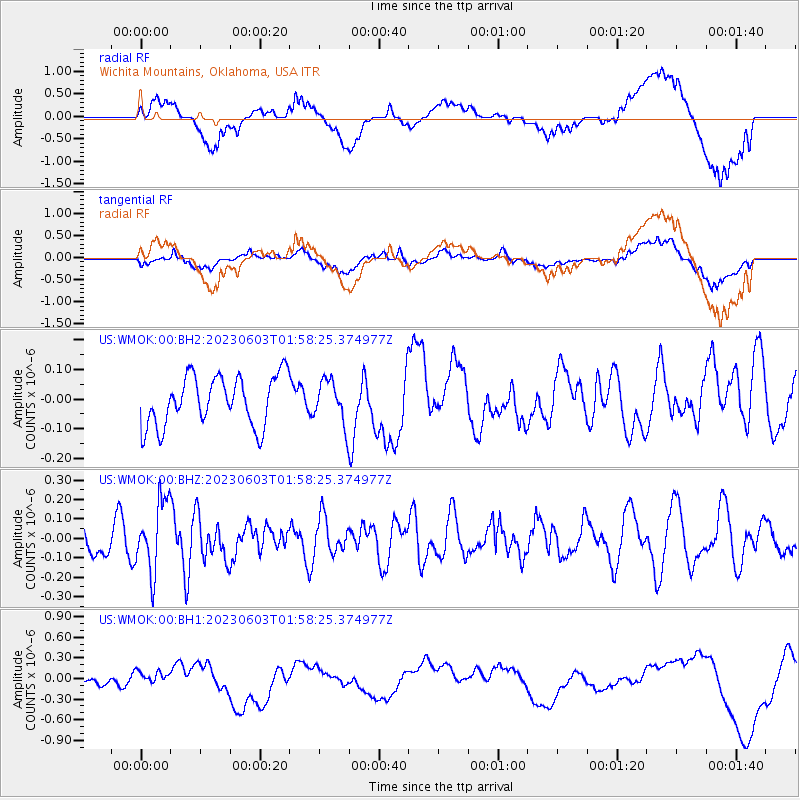
WMOK Wichita Mountains, Oklahoma, USA - Earthquake Result Viewer
*The percent match for this event was below the threshold and hence no stack was calculated.
| Earthquake location: |
Southern Peru |
| Earthquake latitude/longitude: |
-15.7/-71.7 |
| Earthquake time(UTC): |
2023/06/03 (154) 01:49:15 GMT |
| Earthquake Depth: |
10 km |
| Earthquake Magnitude: |
5.5 Mww |
| Earthquake Catalog/Contributor: |
NEIC PDE/us |
|
| Network: |
US United States National Seismic Network |
| Station: |
WMOK Wichita Mountains, Oklahoma, USA |
| Lat/Lon: |
34.74 N/98.78 W |
| Elevation: |
486 m |
|
| Distance: |
56.4 deg |
| Az: |
333.277 deg |
| Baz: |
148.273 deg |
| Ray Param: |
$rayparam |
*The percent match for this event was below the threshold and hence was not used in the summary stack. |
|
| Radial Match: |
70.16371 % |
| Radial Bump: |
400 |
| Transverse Match: |
68.44228 % |
| Transverse Bump: |
400 |
| SOD ConfigId: |
30536071 |
| Insert Time: |
2023-06-17 02:12:39.796 +0000 |
| GWidth: |
2.5 |
| Max Bumps: |
400 |
| Tol: |
0.001 |
|
Signal To Noise
| Channel | StoN | STA | LTA |
| US:WMOK:00:BHZ:20230603T01:58:25.374977Z | 3.4601896 | 1.8089501E-7 | 5.227893E-8 |
| US:WMOK:00:BH1:20230603T01:58:25.374977Z | 1.0444193 | 9.736343E-8 | 9.322256E-8 |
| US:WMOK:00:BH2:20230603T01:58:25.374977Z | 0.8666333 | 7.288934E-8 | 8.4106325E-8 |
| Arrivals |
| Ps | |
| PpPs | |
| PsPs/PpSs | |


