You are here: Home > Network List > TA - USArray Transportable Network (new EarthScope stations) Stations List
> Station L24A Wheatland, WY, USA > Earthquake Result Viewer
L24A Wheatland, WY, USA - Earthquake Result Viewer
| Earthquake location: |
Eastern Sea Of Japan |
| Earthquake latitude/longitude: |
43.3/138.4 |
| Earthquake time(UTC): |
2010/03/30 (089) 01:02:53 GMT |
| Earthquake Depth: |
21 km |
| Earthquake Magnitude: |
6.1 MB, 5.3 MS, 5.7 MW, 5.6 MW |
| Earthquake Catalog/Contributor: |
WHDF/NEIC |
|
| Network: |
TA USArray Transportable Network (new EarthScope stations) |
| Station: |
L24A Wheatland, WY, USA |
| Lat/Lon: |
42.04 N/104.93 W |
| Elevation: |
1479 m |
|
| Distance: |
77.8 deg |
| Az: |
42.919 deg |
| Baz: |
318.131 deg |
| Ray Param: |
0.050071362 |
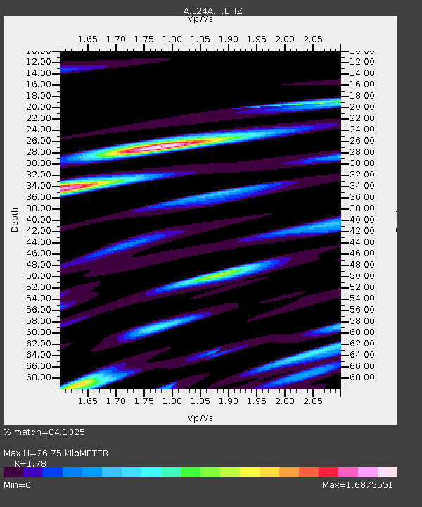
| Estimated Moho Depth: |
26.75 km |
| Estimated Crust Vp/Vs: |
1.78 |
| Assumed Crust Vp: |
6.159 km/s |
| Estimated Crust Vs: |
3.46 km/s |
| Estimated Crust Poisson's Ratio: |
0.27 |
|
| Radial Match: |
84.1325 % |
| Radial Bump: |
372 |
| Transverse Match: |
72.03903 % |
| Transverse Bump: |
400 |
| SOD ConfigId: |
312771 |
| Insert Time: |
2010-06-28 17:30:13.935 +0000 |
| GWidth: |
2.5 |
| Max Bumps: |
400 |
| Tol: |
0.001 |
|

Signal To Noise
| Channel | StoN | STA | LTA |
| TA:L24A: :BHZ:20100330T01:14:17.74998Z | 8.906346 | 1.7987873E-6 | 2.019669E-7 |
| TA:L24A: :BHN:20100330T01:14:17.74998Z | 2.7018032 | 9.519586E-7 | 3.5234197E-7 |
| TA:L24A: :BHE:20100330T01:14:17.74998Z | 3.117845 | 7.466894E-7 | 2.3948894E-7 |
| Arrivals |
| Ps | 3.5 SECOND |
| PpPs | 12 SECOND |
| PsPs/PpSs | 15 SECOND |


