You are here: Home > Network List > G - GEOSCOPE Stations List
> Station KIP Kipapa, Hawai, U.S.A. (Pacific Ocean) > Earthquake Result Viewer
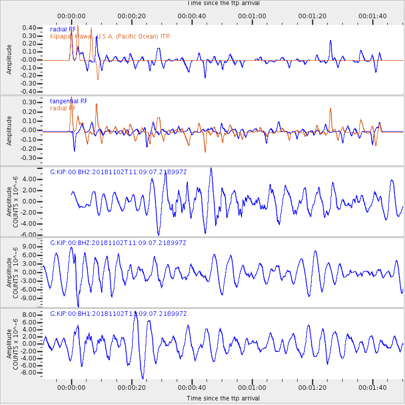
KIP Kipapa, Hawai, U.S.A. (Pacific Ocean) - Earthquake Result Viewer
*The percent match for this event was below the threshold and hence no stack was calculated.
| Earthquake location: |
Northwest Of Kuril Islands |
| Earthquake latitude/longitude: |
47.8/146.7 |
| Earthquake time(UTC): |
2018/11/02 (306) 11:01:15 GMT |
| Earthquake Depth: |
432 km |
| Earthquake Magnitude: |
5.9 Mww |
| Earthquake Catalog/Contributor: |
NEIC PDE/us |
|
| Network: |
G GEOSCOPE |
| Station: |
KIP Kipapa, Hawai, U.S.A. (Pacific Ocean) |
| Lat/Lon: |
21.42 N/158.01 W |
| Elevation: |
70 m |
|
| Distance: |
51.2 deg |
| Az: |
100.899 deg |
| Baz: |
314.74 deg |
| Ray Param: |
$rayparam |
*The percent match for this event was below the threshold and hence was not used in the summary stack. |
|
| Radial Match: |
72.4506 % |
| Radial Bump: |
400 |
| Transverse Match: |
53.45403 % |
| Transverse Bump: |
400 |
| SOD ConfigId: |
3131071 |
| Insert Time: |
2018-11-16 11:10:19.247 +0000 |
| GWidth: |
2.5 |
| Max Bumps: |
400 |
| Tol: |
0.001 |
|
Signal To Noise
| Channel | StoN | STA | LTA |
| G:KIP:00:BHZ:20181102T11:09:07.218997Z | 2.0467052 | 6.474368E-6 | 3.1633126E-6 |
| G:KIP:00:BH1:20181102T11:09:07.218997Z | 2.6357808 | 3.5258001E-6 | 1.3376682E-6 |
| G:KIP:00:BH2:20181102T11:09:07.218997Z | 2.5574265 | 2.8823665E-6 | 1.1270574E-6 |
| Arrivals |
| Ps | |
| PpPs | |
| PsPs/PpSs | |


