You are here: Home > Network List > GS - US Geological Survey Networks Stations List
> Station ASL8 Albuquerque, New Mexico, USA > Earthquake Result Viewer
ASL8 Albuquerque, New Mexico, USA - Earthquake Result Viewer

| Earthquake location: |
Northwest Of Kuril Islands |
| Earthquake latitude/longitude: |
47.8/146.7 |
| Earthquake time(UTC): |
2018/11/02 (306) 11:01:15 GMT |
| Earthquake Depth: |
432 km |
| Earthquake Magnitude: |
5.9 Mww |
| Earthquake Catalog/Contributor: |
NEIC PDE/us |
|
| Network: |
GS US Geological Survey Networks |
| Station: |
ASL8 Albuquerque, New Mexico, USA |
| Lat/Lon: |
34.95 N/106.46 W |
| Elevation: |
1820 m |
|
| Distance: |
74.9 deg |
| Az: |
54.544 deg |
| Baz: |
318.065 deg |
| Ray Param: |
0.050750036 |
| Estimated Moho Depth: |
11.25 km |
| Estimated Crust Vp/Vs: |
1.67 |
| Assumed Crust Vp: |
6.502 km/s |
| Estimated Crust Vs: |
3.893 km/s |
| Estimated Crust Poisson's Ratio: |
0.22 |
|
| Radial Match: |
82.40173 % |
| Radial Bump: |
336 |
| Transverse Match: |
78.97639 % |
| Transverse Bump: |
400 |
| SOD ConfigId: |
3131071 |
| Insert Time: |
2018-11-16 11:10:27.326 +0000 |
| GWidth: |
2.5 |
| Max Bumps: |
400 |
| Tol: |
0.001 |
|
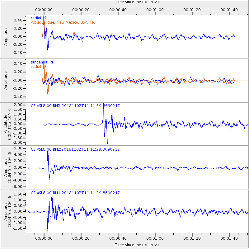
Signal To Noise
| Channel | StoN | STA | LTA |
| GS:ASL8:00:BHZ:20181102T11:11:39.869021Z | 24.154566 | 1.9022668E-6 | 7.875393E-8 |
| GS:ASL8:00:BH1:20181102T11:11:39.869021Z | 11.93548 | 6.635278E-7 | 5.5592892E-8 |
| GS:ASL8:00:BH2:20181102T11:11:39.869021Z | 13.949225 | 8.532611E-7 | 6.116907E-8 |
| Arrivals |
| Ps | 1.2 SECOND |
| PpPs | 4.5 SECOND |
| PsPs/PpSs | 5.7 SECOND |


