You are here: Home > Network List > DK - Danish Seismological Network Stations List
> Station ILULI Ilulissat, Greenland > Earthquake Result Viewer
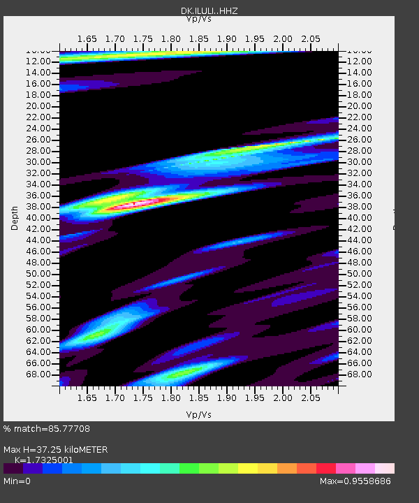
ILULI Ilulissat, Greenland - Earthquake Result Viewer
| Earthquake location: |
Eastern Gulf Of Aden |
| Earthquake latitude/longitude: |
12.6/48.2 |
| Earthquake time(UTC): |
2023/06/03 (154) 07:17:46 GMT |
| Earthquake Depth: |
10 km |
| Earthquake Magnitude: |
5.9 mww |
| Earthquake Catalog/Contributor: |
NEIC PDE/us |
|
| Network: |
DK Danish Seismological Network |
| Station: |
ILULI Ilulissat, Greenland |
| Lat/Lon: |
69.21 N/51.10 W |
| Elevation: |
54 m |
|
| Distance: |
81.6 deg |
| Az: |
339.135 deg |
| Baz: |
76.882 deg |
| Ray Param: |
0.0474963 |
| Estimated Moho Depth: |
37.25 km |
| Estimated Crust Vp/Vs: |
1.73 |
| Assumed Crust Vp: |
6.459 km/s |
| Estimated Crust Vs: |
3.728 km/s |
| Estimated Crust Poisson's Ratio: |
0.25 |
|
| Radial Match: |
85.77708 % |
| Radial Bump: |
400 |
| Transverse Match: |
77.06563 % |
| Transverse Bump: |
400 |
| SOD ConfigId: |
30536071 |
| Insert Time: |
2023-06-17 07:21:46.268 +0000 |
| GWidth: |
2.5 |
| Max Bumps: |
400 |
| Tol: |
0.001 |
|

Signal To Noise
| Channel | StoN | STA | LTA |
| DK:ILULI: :HHZ:20230603T07:29:32.530006Z | 6.672313 | 7.793401E-7 | 1.1680208E-7 |
| DK:ILULI: :HHN:20230603T07:29:32.530006Z | 1.376382 | 1.12025184E-7 | 8.139106E-8 |
| DK:ILULI: :HHE:20230603T07:29:32.530006Z | 4.1132445 | 3.186609E-7 | 7.747192E-8 |
| Arrivals |
| Ps | 4.3 SECOND |
| PpPs | 15 SECOND |
| PsPs/PpSs | 20 SECOND |


