You are here: Home > Network List > EI - Irish National Seismic Network (INSN) Stations List
> Station IDGL INCH ISLAND, CO DONEGAL, IRELAND > Earthquake Result Viewer
IDGL INCH ISLAND, CO DONEGAL, IRELAND - Earthquake Result Viewer
| Earthquake location: |
Eastern Gulf Of Aden |
| Earthquake latitude/longitude: |
12.6/48.2 |
| Earthquake time(UTC): |
2023/06/03 (154) 07:17:46 GMT |
| Earthquake Depth: |
10 km |
| Earthquake Magnitude: |
5.9 mww |
| Earthquake Catalog/Contributor: |
NEIC PDE/us |
|
| Network: |
EI Irish National Seismic Network (INSN) |
| Station: |
IDGL INCH ISLAND, CO DONEGAL, IRELAND |
| Lat/Lon: |
55.07 N/7.51 W |
| Elevation: |
123 m |
|
| Distance: |
60.4 deg |
| Az: |
326.884 deg |
| Baz: |
111.977 deg |
| Ray Param: |
0.061571073 |
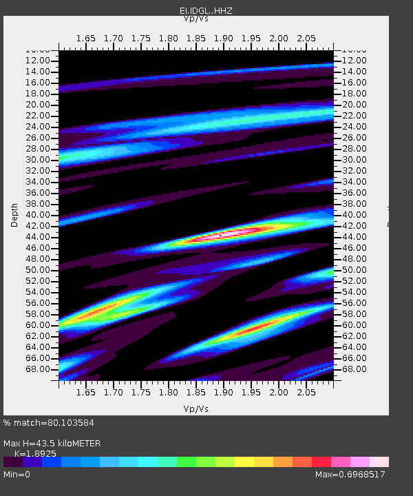
| Estimated Moho Depth: |
43.5 km |
| Estimated Crust Vp/Vs: |
1.89 |
| Assumed Crust Vp: |
6.276 km/s |
| Estimated Crust Vs: |
3.316 km/s |
| Estimated Crust Poisson's Ratio: |
0.31 |
|
| Radial Match: |
80.103584 % |
| Radial Bump: |
400 |
| Transverse Match: |
63.25209 % |
| Transverse Bump: |
400 |
| SOD ConfigId: |
30536071 |
| Insert Time: |
2023-06-17 07:22:00.846 +0000 |
| GWidth: |
2.5 |
| Max Bumps: |
400 |
| Tol: |
0.001 |
|

Signal To Noise
| Channel | StoN | STA | LTA |
| EI:IDGL: :HHZ:20230603T07:27:24.369972Z | 3.49299 | 4.6149177E-7 | 1.3211941E-7 |
| EI:IDGL: :HHN:20230603T07:27:24.369972Z | 0.85517126 | 1.239109E-7 | 1.44896E-7 |
| EI:IDGL: :HHE:20230603T07:27:24.369972Z | 3.7196832 | 3.309554E-7 | 8.8974076E-8 |
| Arrivals |
| Ps | 6.4 SECOND |
| PpPs | 19 SECOND |
| PsPs/PpSs | 26 SECOND |


