You are here: Home > Network List > GS - US Geological Survey Networks Stations List
> Station DEC06 Boomer > Earthquake Result Viewer
DEC06 Boomer - Earthquake Result Viewer
*The percent match for this event was below the threshold and hence no stack was calculated.
| Earthquake location: |
Northwest Of Kuril Islands |
| Earthquake latitude/longitude: |
47.8/146.7 |
| Earthquake time(UTC): |
2018/11/02 (306) 11:01:15 GMT |
| Earthquake Depth: |
432 km |
| Earthquake Magnitude: |
5.9 Mww |
| Earthquake Catalog/Contributor: |
NEIC PDE/us |
|
| Network: |
GS US Geological Survey Networks |
| Station: |
DEC06 Boomer |
| Lat/Lon: |
39.90 N/88.95 W |
| Elevation: |
215 m |
|
| Distance: |
79.7 deg |
| Az: |
40.222 deg |
| Baz: |
325.547 deg |
| Ray Param: |
$rayparam |
*The percent match for this event was below the threshold and hence was not used in the summary stack. |
|
| Radial Match: |
72.59961 % |
| Radial Bump: |
400 |
| Transverse Match: |
56.76496 % |
| Transverse Bump: |
400 |
| SOD ConfigId: |
3131071 |
| Insert Time: |
2018-11-16 11:10:34.304 +0000 |
| GWidth: |
2.5 |
| Max Bumps: |
400 |
| Tol: |
0.001 |
|
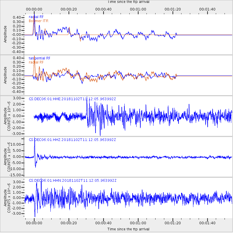
Signal To Noise
| Channel | StoN | STA | LTA |
| GS:DEC06:01:HHZ:20181102T11:12:05.963992Z | 17.928503 | 4.1870576E-6 | 2.3354197E-7 |
| GS:DEC06:01:HHN:20181102T11:12:05.963992Z | 3.4956396 | 1.5850138E-6 | 4.53426E-7 |
| GS:DEC06:01:HHE:20181102T11:12:05.963992Z | 3.4411728 | 1.2074378E-6 | 3.508797E-7 |
| Arrivals |
| Ps | |
| PpPs | |
| PsPs/PpSs | |


