You are here: Home > Network List > GS - US Geological Survey Networks Stations List
> Station KAN13 Rinehart Farm > Earthquake Result Viewer
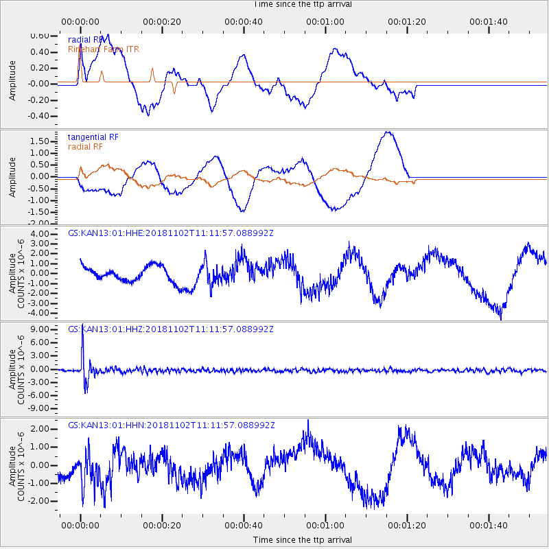
KAN13 Rinehart Farm - Earthquake Result Viewer
*The percent match for this event was below the threshold and hence no stack was calculated.
| Earthquake location: |
Northwest Of Kuril Islands |
| Earthquake latitude/longitude: |
47.8/146.7 |
| Earthquake time(UTC): |
2018/11/02 (306) 11:01:15 GMT |
| Earthquake Depth: |
432 km |
| Earthquake Magnitude: |
5.9 Mww |
| Earthquake Catalog/Contributor: |
NEIC PDE/us |
|
| Network: |
GS US Geological Survey Networks |
| Station: |
KAN13 Rinehart Farm |
| Lat/Lon: |
37.01 N/97.48 W |
| Elevation: |
340 m |
|
| Distance: |
78.0 deg |
| Az: |
47.454 deg |
| Baz: |
321.659 deg |
| Ray Param: |
$rayparam |
*The percent match for this event was below the threshold and hence was not used in the summary stack. |
|
| Radial Match: |
42.347378 % |
| Radial Bump: |
400 |
| Transverse Match: |
52.427715 % |
| Transverse Bump: |
400 |
| SOD ConfigId: |
3131071 |
| Insert Time: |
2018-11-16 11:10:48.606 +0000 |
| GWidth: |
2.5 |
| Max Bumps: |
400 |
| Tol: |
0.001 |
|
Signal To Noise
| Channel | StoN | STA | LTA |
| GS:KAN13:01:HHZ:20181102T11:11:57.088992Z | 14.082087 | 2.8959932E-6 | 2.0565086E-7 |
| GS:KAN13:01:HHN:20181102T11:11:57.088992Z | 1.4794205 | 8.9930023E-7 | 6.078733E-7 |
| GS:KAN13:01:HHE:20181102T11:11:57.088992Z | 1.3804094 | 1.0301926E-6 | 7.4629503E-7 |
| Arrivals |
| Ps | |
| PpPs | |
| PsPs/PpSs | |


