You are here: Home > Network List > TM - Thai Seismic Monitoring Network Stations List
> Station LOEI Nam Man, Loei > Earthquake Result Viewer
LOEI Nam Man, Loei - Earthquake Result Viewer
| Earthquake location: |
Eastern Gulf Of Aden |
| Earthquake latitude/longitude: |
12.6/48.2 |
| Earthquake time(UTC): |
2023/06/03 (154) 07:17:46 GMT |
| Earthquake Depth: |
10 km |
| Earthquake Magnitude: |
5.9 mww |
| Earthquake Catalog/Contributor: |
NEIC PDE/us |
|
| Network: |
TM Thai Seismic Monitoring Network |
| Station: |
LOEI Nam Man, Loei |
| Lat/Lon: |
17.51 N/101.62 E |
| Elevation: |
305 m |
|
| Distance: |
51.7 deg |
| Az: |
77.597 deg |
| Baz: |
272.427 deg |
| Ray Param: |
0.06724068 |
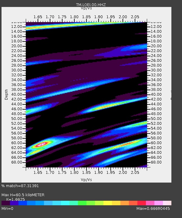
| Estimated Moho Depth: |
60.5 km |
| Estimated Crust Vp/Vs: |
1.66 |
| Assumed Crust Vp: |
6.35 km/s |
| Estimated Crust Vs: |
3.82 km/s |
| Estimated Crust Poisson's Ratio: |
0.22 |
|
| Radial Match: |
87.31391 % |
| Radial Bump: |
313 |
| Transverse Match: |
81.60565 % |
| Transverse Bump: |
383 |
| SOD ConfigId: |
30536071 |
| Insert Time: |
2023-06-17 07:27:38.845 +0000 |
| GWidth: |
2.5 |
| Max Bumps: |
400 |
| Tol: |
0.001 |
|

Signal To Noise
| Channel | StoN | STA | LTA |
| TM:LOEI:00:HHZ:20230603T07:26:22.360023Z | 17.641504 | 9.4339913E-7 | 5.3476114E-8 |
| TM:LOEI:00:HHN:20230603T07:26:22.360023Z | 3.16125 | 1.2520987E-7 | 3.9607706E-8 |
| TM:LOEI:00:HHE:20230603T07:26:22.360023Z | 11.358481 | 4.6271202E-7 | 4.0737138E-8 |
| Arrivals |
| Ps | 6.7 SECOND |
| PpPs | 24 SECOND |
| PsPs/PpSs | 31 SECOND |


