You are here: Home > Network List > TA - USArray Transportable Network (new EarthScope stations) Stations List
> Station R23A Moffat, CO, USA > Earthquake Result Viewer
R23A Moffat, CO, USA - Earthquake Result Viewer
| Earthquake location: |
Eastern Sea Of Japan |
| Earthquake latitude/longitude: |
43.3/138.4 |
| Earthquake time(UTC): |
2010/03/30 (089) 01:02:53 GMT |
| Earthquake Depth: |
21 km |
| Earthquake Magnitude: |
6.1 MB, 5.3 MS, 5.7 MW, 5.6 MW |
| Earthquake Catalog/Contributor: |
WHDF/NEIC |
|
| Network: |
TA USArray Transportable Network (new EarthScope stations) |
| Station: |
R23A Moffat, CO, USA |
| Lat/Lon: |
38.19 N/105.83 W |
| Elevation: |
2547 m |
|
| Distance: |
80.2 deg |
| Az: |
46.054 deg |
| Baz: |
318.157 deg |
| Ray Param: |
0.04842881 |
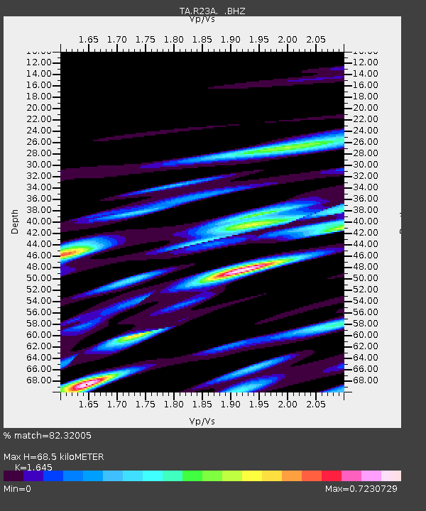
| Estimated Moho Depth: |
68.5 km |
| Estimated Crust Vp/Vs: |
1.64 |
| Assumed Crust Vp: |
6.159 km/s |
| Estimated Crust Vs: |
3.744 km/s |
| Estimated Crust Poisson's Ratio: |
0.21 |
|
| Radial Match: |
82.32005 % |
| Radial Bump: |
400 |
| Transverse Match: |
71.573105 % |
| Transverse Bump: |
400 |
| SOD ConfigId: |
312771 |
| Insert Time: |
2010-06-28 17:36:02.944 +0000 |
| GWidth: |
2.5 |
| Max Bumps: |
400 |
| Tol: |
0.001 |
|
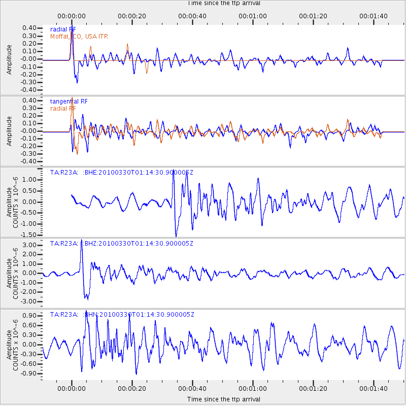
Signal To Noise
| Channel | StoN | STA | LTA |
| TA:R23A: :BHZ:20100330T01:14:30.900005Z | 8.4527445 | 1.3985093E-6 | 1.6545033E-7 |
| TA:R23A: :BHN:20100330T01:14:30.900005Z | 1.9715748 | 3.670221E-7 | 1.8615681E-7 |
| TA:R23A: :BHE:20100330T01:14:30.900005Z | 3.1554189 | 6.2816923E-7 | 1.9907633E-7 |
| Arrivals |
| Ps | 7.4 SECOND |
| PpPs | 29 SECOND |
| PsPs/PpSs | 36 SECOND |


