You are here: Home > Network List > IU - Global Seismograph Network (GSN - IRIS/USGS) Stations List
> Station PMG Port Moresby, New Guinea > Earthquake Result Viewer
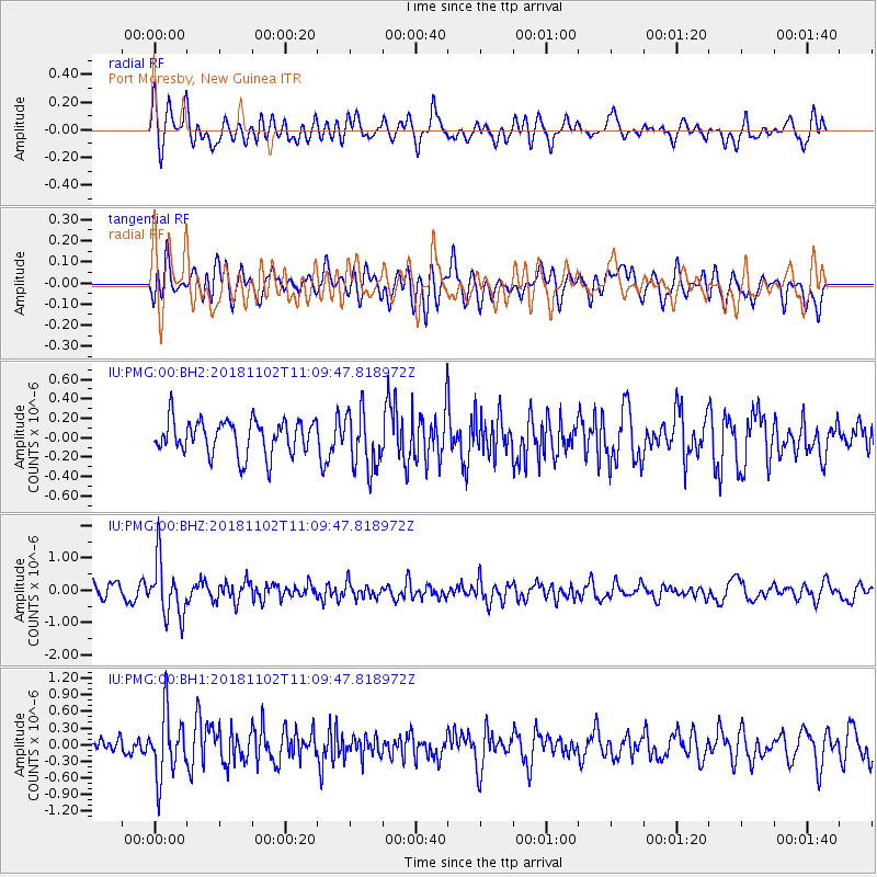
PMG Port Moresby, New Guinea - Earthquake Result Viewer
*The percent match for this event was below the threshold and hence no stack was calculated.
| Earthquake location: |
Northwest Of Kuril Islands |
| Earthquake latitude/longitude: |
47.8/146.7 |
| Earthquake time(UTC): |
2018/11/02 (306) 11:01:15 GMT |
| Earthquake Depth: |
432 km |
| Earthquake Magnitude: |
5.9 Mww |
| Earthquake Catalog/Contributor: |
NEIC PDE/us |
|
| Network: |
IU Global Seismograph Network (GSN - IRIS/USGS) |
| Station: |
PMG Port Moresby, New Guinea |
| Lat/Lon: |
9.40 S/147.16 E |
| Elevation: |
90 m |
|
| Distance: |
57.0 deg |
| Az: |
179.48 deg |
| Baz: |
359.645 deg |
| Ray Param: |
$rayparam |
*The percent match for this event was below the threshold and hence was not used in the summary stack. |
|
| Radial Match: |
68.537056 % |
| Radial Bump: |
400 |
| Transverse Match: |
53.91368 % |
| Transverse Bump: |
400 |
| SOD ConfigId: |
3131071 |
| Insert Time: |
2018-11-16 11:11:54.008 +0000 |
| GWidth: |
2.5 |
| Max Bumps: |
400 |
| Tol: |
0.001 |
|
Signal To Noise
| Channel | StoN | STA | LTA |
| IU:PMG:00:BHZ:20181102T11:09:47.818972Z | 4.213633 | 8.62848E-7 | 2.047753E-7 |
| IU:PMG:00:BH1:20181102T11:09:47.818972Z | 3.356288 | 5.7136424E-7 | 1.7023696E-7 |
| IU:PMG:00:BH2:20181102T11:09:47.818972Z | 1.6891912 | 2.9859967E-7 | 1.767708E-7 |
| Arrivals |
| Ps | |
| PpPs | |
| PsPs/PpSs | |


