You are here: Home > Network List > IW - Intermountain West Stations List
> Station DLMT Dillon, Montana, USA > Earthquake Result Viewer
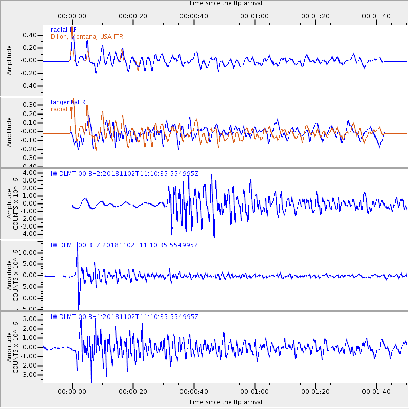
DLMT Dillon, Montana, USA - Earthquake Result Viewer
*The percent match for this event was below the threshold and hence no stack was calculated.
| Earthquake location: |
Northwest Of Kuril Islands |
| Earthquake latitude/longitude: |
47.8/146.7 |
| Earthquake time(UTC): |
2018/11/02 (306) 11:01:15 GMT |
| Earthquake Depth: |
432 km |
| Earthquake Magnitude: |
5.9 Mww |
| Earthquake Catalog/Contributor: |
NEIC PDE/us |
|
| Network: |
IW Intermountain West |
| Station: |
DLMT Dillon, Montana, USA |
| Lat/Lon: |
45.36 N/112.60 W |
| Elevation: |
1569 m |
|
| Distance: |
64.2 deg |
| Az: |
50.329 deg |
| Baz: |
312.621 deg |
| Ray Param: |
$rayparam |
*The percent match for this event was below the threshold and hence was not used in the summary stack. |
|
| Radial Match: |
79.7854 % |
| Radial Bump: |
400 |
| Transverse Match: |
82.41931 % |
| Transverse Bump: |
400 |
| SOD ConfigId: |
3131071 |
| Insert Time: |
2018-11-16 11:12:06.471 +0000 |
| GWidth: |
2.5 |
| Max Bumps: |
400 |
| Tol: |
0.001 |
|
Signal To Noise
| Channel | StoN | STA | LTA |
| IW:DLMT:00:BHZ:20181102T11:10:35.554995Z | 50.10038 | 5.321223E-6 | 1.0621123E-7 |
| IW:DLMT:00:BH1:20181102T11:10:35.554995Z | 6.493102 | 1.1709124E-6 | 1.8033172E-7 |
| IW:DLMT:00:BH2:20181102T11:10:35.554995Z | 4.9920225 | 1.5109136E-6 | 3.0266563E-7 |
| Arrivals |
| Ps | |
| PpPs | |
| PsPs/PpSs | |


