You are here: Home > Network List > TA - USArray Transportable Network (new EarthScope stations) Stations List
> Station 129A Stewart Farms, Lamesa, TX, USA > Earthquake Result Viewer
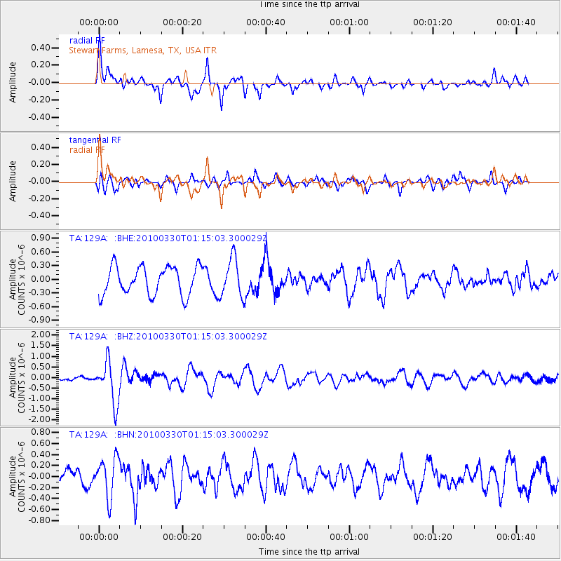
129A Stewart Farms, Lamesa, TX, USA - Earthquake Result Viewer
*The percent match for this event was below the threshold and hence no stack was calculated.
| Earthquake location: |
Eastern Sea Of Japan |
| Earthquake latitude/longitude: |
43.3/138.4 |
| Earthquake time(UTC): |
2010/03/30 (089) 01:02:53 GMT |
| Earthquake Depth: |
21 km |
| Earthquake Magnitude: |
6.1 MB, 5.3 MS, 5.7 MW, 5.6 MW |
| Earthquake Catalog/Contributor: |
WHDF/NEIC |
|
| Network: |
TA USArray Transportable Network (new EarthScope stations) |
| Station: |
129A Stewart Farms, Lamesa, TX, USA |
| Lat/Lon: |
32.63 N/101.87 W |
| Elevation: |
876 m |
|
| Distance: |
86.5 deg |
| Az: |
47.217 deg |
| Baz: |
320.58 deg |
| Ray Param: |
$rayparam |
*The percent match for this event was below the threshold and hence was not used in the summary stack. |
|
| Radial Match: |
69.18365 % |
| Radial Bump: |
400 |
| Transverse Match: |
32.66981 % |
| Transverse Bump: |
393 |
| SOD ConfigId: |
312771 |
| Insert Time: |
2010-06-28 17:39:26.368 +0000 |
| GWidth: |
2.5 |
| Max Bumps: |
400 |
| Tol: |
0.001 |
|
Signal To Noise
| Channel | StoN | STA | LTA |
| TA:129A: :BHZ:20100330T01:15:03.300029Z | 5.8808084 | 1.0150566E-6 | 1.7260494E-7 |
| TA:129A: :BHN:20100330T01:15:03.300029Z | 2.0611193 | 3.6271422E-7 | 1.7597924E-7 |
| TA:129A: :BHE:20100330T01:15:03.300029Z | 1.3710626 | 4.2578682E-7 | 3.1055242E-7 |
| Arrivals |
| Ps | |
| PpPs | |
| PsPs/PpSs | |


