You are here: Home > Network List > TA - USArray Transportable Network (new EarthScope stations) Stations List
> Station 431A Sonora, TX, USA > Earthquake Result Viewer
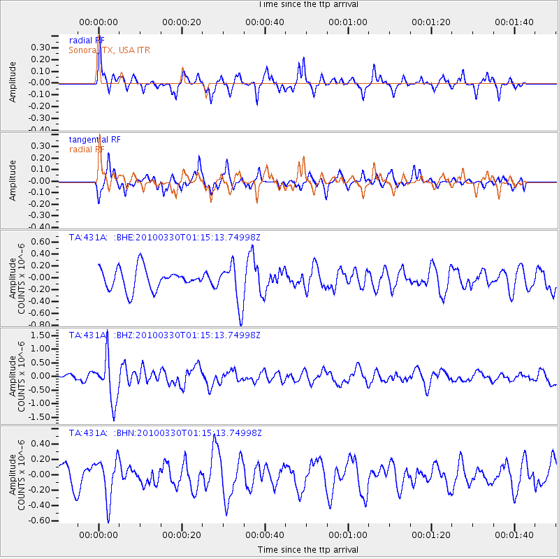
431A Sonora, TX, USA - Earthquake Result Viewer
*The percent match for this event was below the threshold and hence no stack was calculated.
| Earthquake location: |
Eastern Sea Of Japan |
| Earthquake latitude/longitude: |
43.3/138.4 |
| Earthquake time(UTC): |
2010/03/30 (089) 01:02:53 GMT |
| Earthquake Depth: |
21 km |
| Earthquake Magnitude: |
6.1 MB, 5.3 MS, 5.7 MW, 5.6 MW |
| Earthquake Catalog/Contributor: |
WHDF/NEIC |
|
| Network: |
TA USArray Transportable Network (new EarthScope stations) |
| Station: |
431A Sonora, TX, USA |
| Lat/Lon: |
30.68 N/100.61 W |
| Elevation: |
700 m |
|
| Distance: |
88.7 deg |
| Az: |
47.609 deg |
| Baz: |
321.254 deg |
| Ray Param: |
$rayparam |
*The percent match for this event was below the threshold and hence was not used in the summary stack. |
|
| Radial Match: |
65.416336 % |
| Radial Bump: |
324 |
| Transverse Match: |
62.77216 % |
| Transverse Bump: |
337 |
| SOD ConfigId: |
312771 |
| Insert Time: |
2010-06-28 17:40:07.229 +0000 |
| GWidth: |
2.5 |
| Max Bumps: |
400 |
| Tol: |
0.001 |
|
Signal To Noise
| Channel | StoN | STA | LTA |
| TA:431A: :BHZ:20100330T01:15:13.74998Z | 6.2064366 | 8.252926E-7 | 1.3297365E-7 |
| TA:431A: :BHN:20100330T01:15:13.74998Z | 2.0960724 | 2.6866846E-7 | 1.2817708E-7 |
| TA:431A: :BHE:20100330T01:15:13.74998Z | 2.077461 | 3.649844E-7 | 1.7568773E-7 |
| Arrivals |
| Ps | |
| PpPs | |
| PsPs/PpSs | |


