You are here: Home > Network List > AV - Alaska Volcano Observatory Stations List
> Station MAPS Pakushin Southeast, Makushin Volcano, Alaska > Earthquake Result Viewer
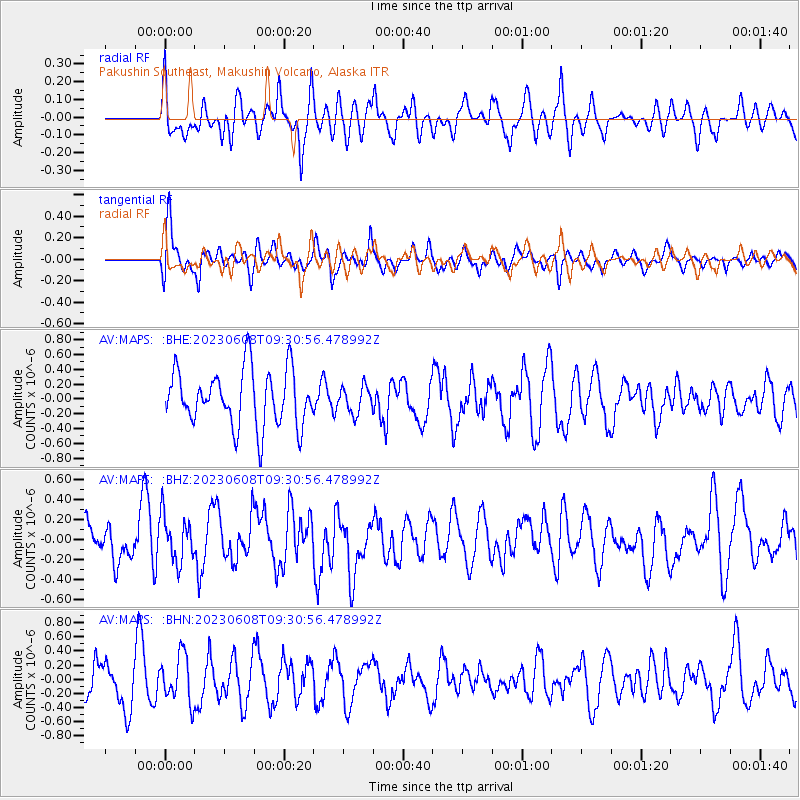
MAPS Pakushin Southeast, Makushin Volcano, Alaska - Earthquake Result Viewer
*The percent match for this event was below the threshold and hence no stack was calculated.
| Earthquake location: |
Southeast Of Loyalty Islands |
| Earthquake latitude/longitude: |
-22.4/170.3 |
| Earthquake time(UTC): |
2023/06/08 (159) 09:19:28 GMT |
| Earthquake Depth: |
18 km |
| Earthquake Magnitude: |
5.7 mww |
| Earthquake Catalog/Contributor: |
NEIC PDE/us |
|
| Network: |
AV Alaska Volcano Observatory |
| Station: |
MAPS Pakushin Southeast, Makushin Volcano, Alaska |
| Lat/Lon: |
53.81 N/166.94 W |
| Elevation: |
333 m |
|
| Distance: |
78.4 deg |
| Az: |
13.565 deg |
| Baz: |
201.477 deg |
| Ray Param: |
$rayparam |
*The percent match for this event was below the threshold and hence was not used in the summary stack. |
|
| Radial Match: |
44.782715 % |
| Radial Bump: |
400 |
| Transverse Match: |
62.961678 % |
| Transverse Bump: |
400 |
| SOD ConfigId: |
30536071 |
| Insert Time: |
2023-06-22 09:24:45.318 +0000 |
| GWidth: |
2.5 |
| Max Bumps: |
400 |
| Tol: |
0.001 |
|
Signal To Noise
| Channel | StoN | STA | LTA |
| AV:MAPS: :BHZ:20230608T09:30:56.478992Z | 1.3291742 | 2.4507077E-7 | 1.8437822E-7 |
| AV:MAPS: :BHN:20230608T09:30:56.478992Z | 1.2132359 | 3.3400804E-7 | 2.7530348E-7 |
| AV:MAPS: :BHE:20230608T09:30:56.478992Z | 0.4646577 | 1.7669848E-7 | 3.8027667E-7 |
| Arrivals |
| Ps | |
| PpPs | |
| PsPs/PpSs | |


