You are here: Home > Network List > TA - USArray Transportable Network (new EarthScope stations) Stations List
> Station TOLK Toolik Lake Research Station, AK, USA > Earthquake Result Viewer
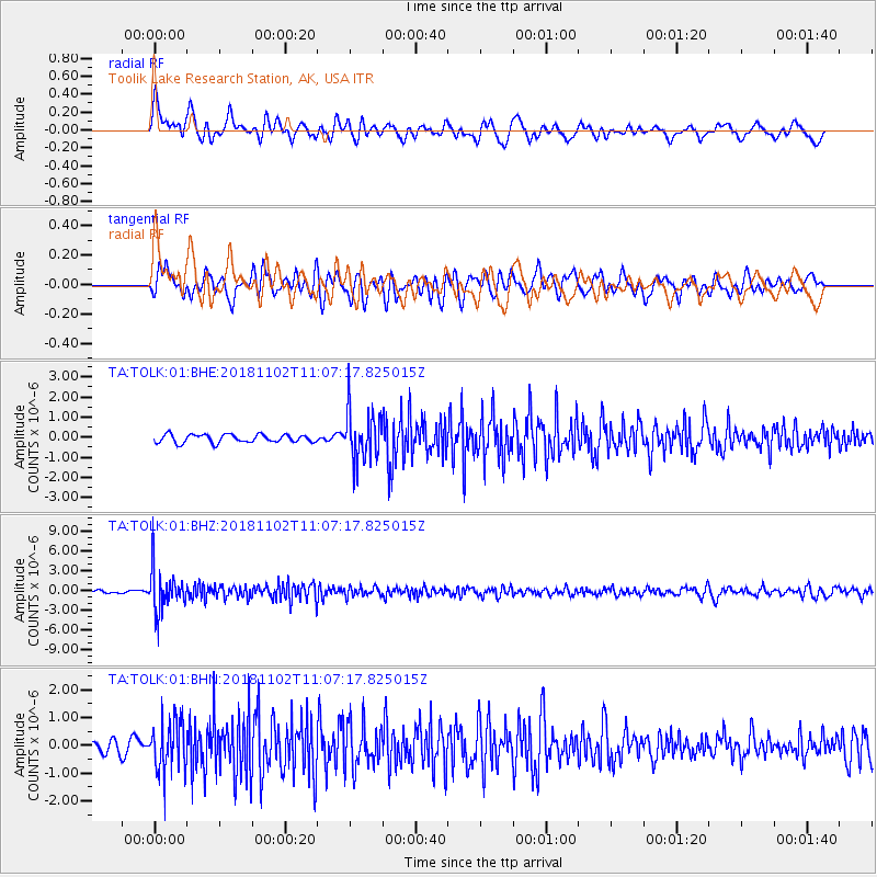
TOLK Toolik Lake Research Station, AK, USA - Earthquake Result Viewer
*The percent match for this event was below the threshold and hence no stack was calculated.
| Earthquake location: |
Northwest Of Kuril Islands |
| Earthquake latitude/longitude: |
47.8/146.7 |
| Earthquake time(UTC): |
2018/11/02 (306) 11:01:15 GMT |
| Earthquake Depth: |
432 km |
| Earthquake Magnitude: |
5.9 Mww |
| Earthquake Catalog/Contributor: |
NEIC PDE/us |
|
| Network: |
TA USArray Transportable Network (new EarthScope stations) |
| Station: |
TOLK Toolik Lake Research Station, AK, USA |
| Lat/Lon: |
68.64 N/149.57 W |
| Elevation: |
760 m |
|
| Distance: |
37.2 deg |
| Az: |
32.923 deg |
| Baz: |
269.324 deg |
| Ray Param: |
$rayparam |
*The percent match for this event was below the threshold and hence was not used in the summary stack. |
|
| Radial Match: |
72.343414 % |
| Radial Bump: |
400 |
| Transverse Match: |
62.42422 % |
| Transverse Bump: |
400 |
| SOD ConfigId: |
3131071 |
| Insert Time: |
2018-11-16 11:13:50.990 +0000 |
| GWidth: |
2.5 |
| Max Bumps: |
400 |
| Tol: |
0.001 |
|
Signal To Noise
| Channel | StoN | STA | LTA |
| TA:TOLK:01:BHZ:20181102T11:07:17.825015Z | 12.451914 | 3.1741113E-6 | 2.549095E-7 |
| TA:TOLK:01:BHN:20181102T11:07:17.825015Z | 3.3930542 | 9.001613E-7 | 2.6529528E-7 |
| TA:TOLK:01:BHE:20181102T11:07:17.825015Z | 6.0670595 | 1.240316E-6 | 2.0443444E-7 |
| Arrivals |
| Ps | |
| PpPs | |
| PsPs/PpSs | |


