You are here: Home > Network List > TA - USArray Transportable Network (new EarthScope stations) Stations List
> Station H29A Onida, SD, USA > Earthquake Result Viewer
H29A Onida, SD, USA - Earthquake Result Viewer
| Earthquake location: |
Eastern Sea Of Japan |
| Earthquake latitude/longitude: |
43.3/138.4 |
| Earthquake time(UTC): |
2010/03/30 (089) 01:02:53 GMT |
| Earthquake Depth: |
21 km |
| Earthquake Magnitude: |
6.1 MB, 5.3 MS, 5.7 MW, 5.6 MW |
| Earthquake Catalog/Contributor: |
WHDF/NEIC |
|
| Network: |
TA USArray Transportable Network (new EarthScope stations) |
| Station: |
H29A Onida, SD, USA |
| Lat/Lon: |
44.63 N/100.21 W |
| Elevation: |
548 m |
|
| Distance: |
78.1 deg |
| Az: |
38.528 deg |
| Baz: |
320.442 deg |
| Ray Param: |
0.049873322 |
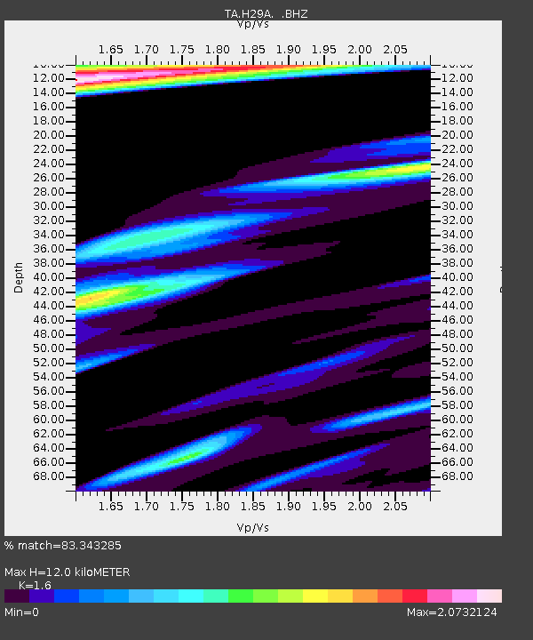
| Estimated Moho Depth: |
12.0 km |
| Estimated Crust Vp/Vs: |
1.60 |
| Assumed Crust Vp: |
6.53 km/s |
| Estimated Crust Vs: |
4.082 km/s |
| Estimated Crust Poisson's Ratio: |
0.18 |
|
| Radial Match: |
83.343285 % |
| Radial Bump: |
366 |
| Transverse Match: |
56.418484 % |
| Transverse Bump: |
379 |
| SOD ConfigId: |
312771 |
| Insert Time: |
2010-06-28 17:49:48.644 +0000 |
| GWidth: |
2.5 |
| Max Bumps: |
400 |
| Tol: |
0.001 |
|
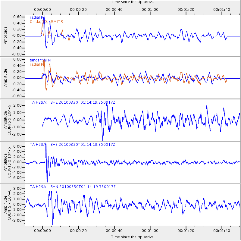
Signal To Noise
| Channel | StoN | STA | LTA |
| TA:H29A: :BHZ:20100330T01:14:19.350017Z | 11.74472 | 3.0492672E-6 | 2.5962876E-7 |
| TA:H29A: :BHN:20100330T01:14:19.350017Z | 1.9102554 | 1.1263342E-6 | 5.896249E-7 |
| TA:H29A: :BHE:20100330T01:14:19.350017Z | 2.8982055 | 1.1180114E-6 | 3.8575988E-7 |
| Arrivals |
| Ps | 1.1 SECOND |
| PpPs | 4.6 SECOND |
| PsPs/PpSs | 5.8 SECOND |


