You are here: Home > Network List > TA - USArray Transportable Network (new EarthScope stations) Stations List
> Station U34A Anderson Ranch, Garber, OK, USA > Earthquake Result Viewer
U34A Anderson Ranch, Garber, OK, USA - Earthquake Result Viewer
*The percent match for this event was below the threshold and hence no stack was calculated.
| Earthquake location: |
Eastern Sea Of Japan |
| Earthquake latitude/longitude: |
43.3/138.4 |
| Earthquake time(UTC): |
2010/03/30 (089) 01:02:53 GMT |
| Earthquake Depth: |
21 km |
| Earthquake Magnitude: |
6.1 MB, 5.3 MS, 5.7 MW, 5.6 MW |
| Earthquake Catalog/Contributor: |
WHDF/NEIC |
|
| Network: |
TA USArray Transportable Network (new EarthScope stations) |
| Station: |
U34A Anderson Ranch, Garber, OK, USA |
| Lat/Lon: |
36.44 N/97.54 W |
| Elevation: |
345 m |
|
| Distance: |
85.7 deg |
| Az: |
42.046 deg |
| Baz: |
322.676 deg |
| Ray Param: |
$rayparam |
*The percent match for this event was below the threshold and hence was not used in the summary stack. |
|
| Radial Match: |
74.44768 % |
| Radial Bump: |
379 |
| Transverse Match: |
75.415794 % |
| Transverse Bump: |
400 |
| SOD ConfigId: |
312771 |
| Insert Time: |
2010-06-28 17:51:32.388 +0000 |
| GWidth: |
2.5 |
| Max Bumps: |
400 |
| Tol: |
0.001 |
|
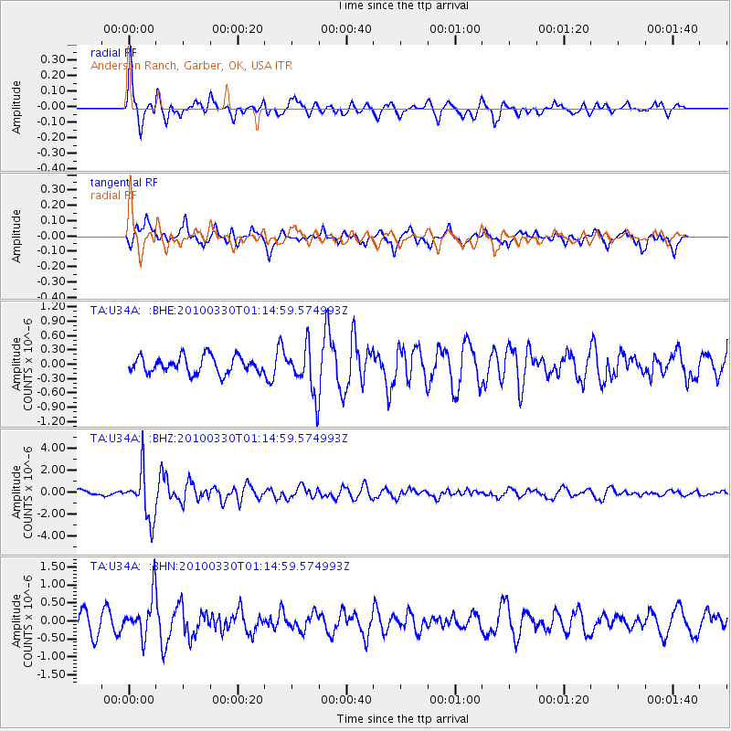
Signal To Noise
| Channel | StoN | STA | LTA |
| TA:U34A: :BHZ:20100330T01:14:59.574993Z | 8.525658 | 2.1865246E-6 | 2.5646403E-7 |
| TA:U34A: :BHN:20100330T01:14:59.574993Z | 2.1308908 | 5.681367E-7 | 2.6661937E-7 |
| TA:U34A: :BHE:20100330T01:14:59.574993Z | 2.861457 | 4.9667005E-7 | 1.7357243E-7 |
| Arrivals |
| Ps | |
| PpPs | |
| PsPs/PpSs | |


