You are here: Home > Network List > TX - Texas Seismological Network Stations List
> Station PB08 Permian Basin 08 > Earthquake Result Viewer
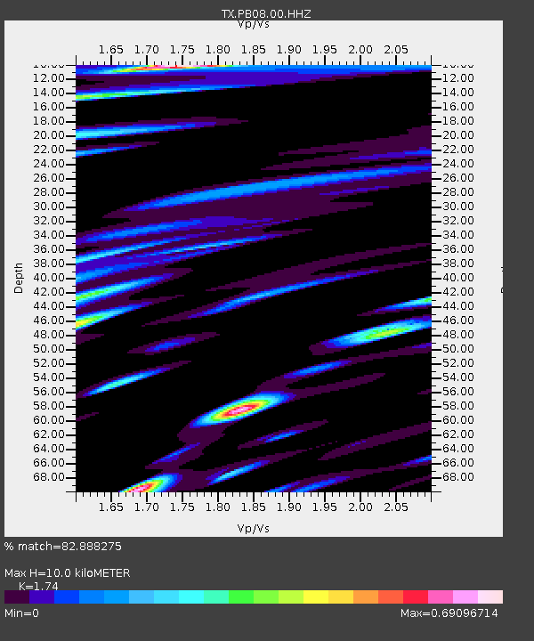
PB08 Permian Basin 08 - Earthquake Result Viewer
| Earthquake location: |
Northwest Of Kuril Islands |
| Earthquake latitude/longitude: |
47.8/146.7 |
| Earthquake time(UTC): |
2018/11/02 (306) 11:01:15 GMT |
| Earthquake Depth: |
432 km |
| Earthquake Magnitude: |
5.9 Mww |
| Earthquake Catalog/Contributor: |
NEIC PDE/us |
|
| Network: |
TX Texas Seismological Network |
| Station: |
PB08 Permian Basin 08 |
| Lat/Lon: |
30.89 N/102.91 W |
| Elevation: |
926 m |
|
| Distance: |
79.9 deg |
| Az: |
54.945 deg |
| Baz: |
320.074 deg |
| Ray Param: |
0.047432475 |
| Estimated Moho Depth: |
10.0 km |
| Estimated Crust Vp/Vs: |
1.74 |
| Assumed Crust Vp: |
6.121 km/s |
| Estimated Crust Vs: |
3.518 km/s |
| Estimated Crust Poisson's Ratio: |
0.25 |
|
| Radial Match: |
82.888275 % |
| Radial Bump: |
400 |
| Transverse Match: |
69.21834 % |
| Transverse Bump: |
400 |
| SOD ConfigId: |
3131071 |
| Insert Time: |
2018-11-16 11:14:48.683 +0000 |
| GWidth: |
2.5 |
| Max Bumps: |
400 |
| Tol: |
0.001 |
|

Signal To Noise
| Channel | StoN | STA | LTA |
| TX:PB08:00:HHZ:20181102T11:12:07.140017Z | 16.159115 | 3.1007623E-6 | 1.9188936E-7 |
| TX:PB08:00:HH1:20181102T11:12:07.140017Z | 3.3478413 | 4.4726994E-7 | 1.3359951E-7 |
| TX:PB08:00:HH2:20181102T11:12:07.140017Z | 9.613863 | 1.0299435E-6 | 1.0713107E-7 |
| Arrivals |
| Ps | 1.2 SECOND |
| PpPs | 4.4 SECOND |
| PsPs/PpSs | 5.6 SECOND |


