You are here: Home > Network List > AK - Alaska Regional Network Stations List
> Station G17K Kiwalik Mountain, AK, USA > Earthquake Result Viewer
G17K Kiwalik Mountain, AK, USA - Earthquake Result Viewer
| Earthquake location: |
Fiji Islands Region |
| Earthquake latitude/longitude: |
-16.0/-179.2 |
| Earthquake time(UTC): |
2023/06/10 (161) 09:12:50 GMT |
| Earthquake Depth: |
10 km |
| Earthquake Magnitude: |
5.8 mww |
| Earthquake Catalog/Contributor: |
NEIC PDE/us |
|
| Network: |
AK Alaska Regional Network |
| Station: |
G17K Kiwalik Mountain, AK, USA |
| Lat/Lon: |
65.50 N/160.65 W |
| Elevation: |
338 m |
|
| Distance: |
82.4 deg |
| Az: |
7.672 deg |
| Baz: |
197.936 deg |
| Ray Param: |
0.046893787 |
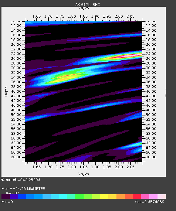
| Estimated Moho Depth: |
24.25 km |
| Estimated Crust Vp/Vs: |
2.07 |
| Assumed Crust Vp: |
6.276 km/s |
| Estimated Crust Vs: |
3.032 km/s |
| Estimated Crust Poisson's Ratio: |
0.35 |
|
| Radial Match: |
84.125206 % |
| Radial Bump: |
357 |
| Transverse Match: |
77.12366 % |
| Transverse Bump: |
400 |
| SOD ConfigId: |
30536071 |
| Insert Time: |
2023-06-24 09:15:18.941 +0000 |
| GWidth: |
2.5 |
| Max Bumps: |
400 |
| Tol: |
0.001 |
|

Signal To Noise
| Channel | StoN | STA | LTA |
| AK:G17K: :BHZ:20230610T09:24:41.760029Z | 2.8864427 | 1.5708399E-7 | 5.4421314E-8 |
| AK:G17K: :BHN:20230610T09:24:41.760029Z | 0.65814936 | 3.028034E-8 | 4.600831E-8 |
| AK:G17K: :BHE:20230610T09:24:41.760029Z | 0.6651093 | 2.1322151E-8 | 3.2058118E-8 |
| Arrivals |
| Ps | 4.2 SECOND |
| PpPs | 12 SECOND |
| PsPs/PpSs | 16 SECOND |


