You are here: Home > Network List > AK - Alaska Regional Network Stations List
> Station L20K Alaska Regional Network > Earthquake Result Viewer
L20K Alaska Regional Network - Earthquake Result Viewer
| Earthquake location: |
Fiji Islands Region |
| Earthquake latitude/longitude: |
-16.0/-179.2 |
| Earthquake time(UTC): |
2023/06/10 (161) 09:12:50 GMT |
| Earthquake Depth: |
10 km |
| Earthquake Magnitude: |
5.8 mww |
| Earthquake Catalog/Contributor: |
NEIC PDE/us |
|
| Network: |
AK Alaska Regional Network |
| Station: |
L20K Alaska Regional Network |
| Lat/Lon: |
62.48 N/153.88 W |
| Elevation: |
673 m |
|
| Distance: |
80.7 deg |
| Az: |
11.595 deg |
| Baz: |
204.593 deg |
| Ray Param: |
0.04810783 |
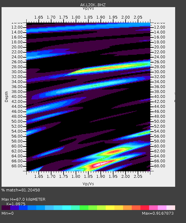
| Estimated Moho Depth: |
67.0 km |
| Estimated Crust Vp/Vs: |
1.90 |
| Assumed Crust Vp: |
6.566 km/s |
| Estimated Crust Vs: |
3.46 km/s |
| Estimated Crust Poisson's Ratio: |
0.31 |
|
| Radial Match: |
81.20458 % |
| Radial Bump: |
400 |
| Transverse Match: |
56.335598 % |
| Transverse Bump: |
400 |
| SOD ConfigId: |
30536071 |
| Insert Time: |
2023-06-24 09:16:12.683 +0000 |
| GWidth: |
2.5 |
| Max Bumps: |
400 |
| Tol: |
0.001 |
|

Signal To Noise
| Channel | StoN | STA | LTA |
| AK:L20K: :BHZ:20230610T09:24:32.579975Z | 2.5859926 | 1.9382566E-7 | 7.495213E-8 |
| AK:L20K: :BHN:20230610T09:24:32.579975Z | 2.0941815 | 1.5080904E-7 | 7.201336E-8 |
| AK:L20K: :BHE:20230610T09:24:32.579975Z | 1.1248695 | 9.7187105E-8 | 8.6398565E-8 |
| Arrivals |
| Ps | 9.4 SECOND |
| PpPs | 29 SECOND |
| PsPs/PpSs | 38 SECOND |


