You are here: Home > Network List > US - United States National Seismic Network Stations List
> Station ERPA Erie, Pennsylvania, USA > Earthquake Result Viewer
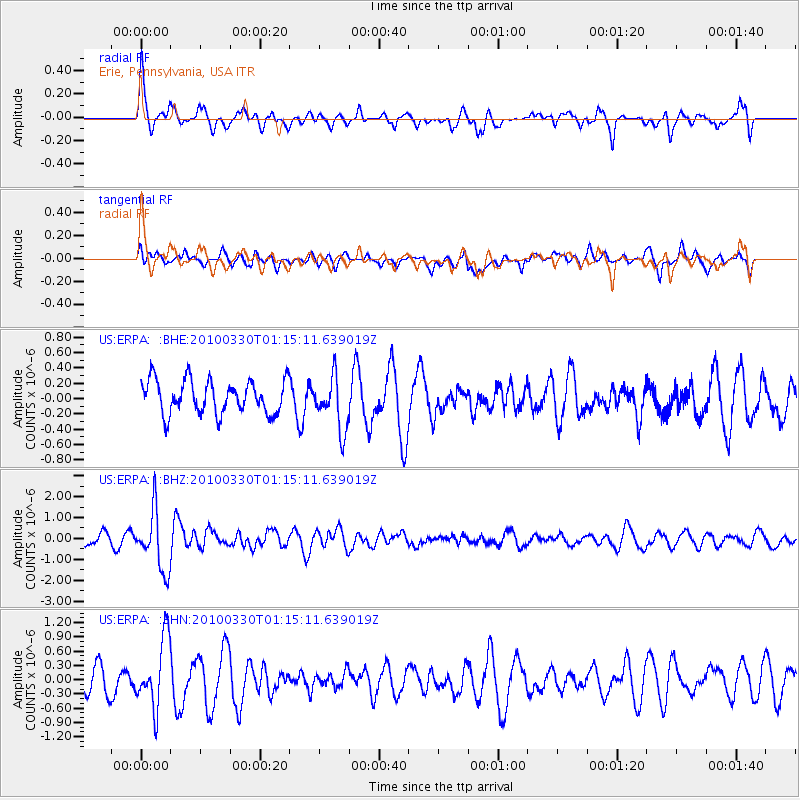
ERPA Erie, Pennsylvania, USA - Earthquake Result Viewer
*The percent match for this event was below the threshold and hence no stack was calculated.
| Earthquake location: |
Eastern Sea Of Japan |
| Earthquake latitude/longitude: |
43.3/138.4 |
| Earthquake time(UTC): |
2010/03/30 (089) 01:02:53 GMT |
| Earthquake Depth: |
21 km |
| Earthquake Magnitude: |
6.1 MB, 5.3 MS, 5.7 MW, 5.6 MW |
| Earthquake Catalog/Contributor: |
WHDF/NEIC |
|
| Network: |
US United States National Seismic Network |
| Station: |
ERPA Erie, Pennsylvania, USA |
| Lat/Lon: |
42.12 N/79.99 W |
| Elevation: |
306 m |
|
| Distance: |
88.2 deg |
| Az: |
27.519 deg |
| Baz: |
333.039 deg |
| Ray Param: |
$rayparam |
*The percent match for this event was below the threshold and hence was not used in the summary stack. |
|
| Radial Match: |
66.51988 % |
| Radial Bump: |
367 |
| Transverse Match: |
65.94222 % |
| Transverse Bump: |
400 |
| SOD ConfigId: |
312771 |
| Insert Time: |
2010-06-28 17:59:40.591 +0000 |
| GWidth: |
2.5 |
| Max Bumps: |
400 |
| Tol: |
0.001 |
|
Signal To Noise
| Channel | StoN | STA | LTA |
| US:ERPA: :BHZ:20100330T01:15:11.639019Z | 7.073525 | 1.4083523E-6 | 1.991019E-7 |
| US:ERPA: :BHN:20100330T01:15:11.639019Z | 2.625642 | 7.224856E-7 | 2.7516532E-7 |
| US:ERPA: :BHE:20100330T01:15:11.639019Z | 1.6066507 | 3.4876678E-7 | 2.1707692E-7 |
| Arrivals |
| Ps | |
| PpPs | |
| PsPs/PpSs | |


