You are here: Home > Network List > US - United States National Seismic Network Stations List
> Station EGMT Eagleton, Montana, USA > Earthquake Result Viewer
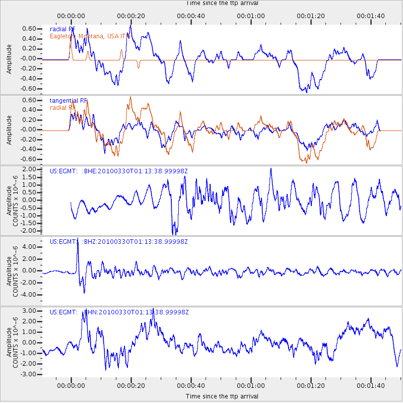
EGMT Eagleton, Montana, USA - Earthquake Result Viewer
*The percent match for this event was below the threshold and hence no stack was calculated.
| Earthquake location: |
Eastern Sea Of Japan |
| Earthquake latitude/longitude: |
43.3/138.4 |
| Earthquake time(UTC): |
2010/03/30 (089) 01:02:53 GMT |
| Earthquake Depth: |
21 km |
| Earthquake Magnitude: |
6.1 MB, 5.3 MS, 5.7 MW, 5.6 MW |
| Earthquake Catalog/Contributor: |
WHDF/NEIC |
|
| Network: |
US United States National Seismic Network |
| Station: |
EGMT Eagleton, Montana, USA |
| Lat/Lon: |
48.02 N/109.75 W |
| Elevation: |
1055 m |
|
| Distance: |
71.1 deg |
| Az: |
41.188 deg |
| Baz: |
314.26 deg |
| Ray Param: |
$rayparam |
*The percent match for this event was below the threshold and hence was not used in the summary stack. |
|
| Radial Match: |
33.57475 % |
| Radial Bump: |
400 |
| Transverse Match: |
37.19634 % |
| Transverse Bump: |
400 |
| SOD ConfigId: |
312771 |
| Insert Time: |
2010-06-28 18:00:04.868 +0000 |
| GWidth: |
2.5 |
| Max Bumps: |
400 |
| Tol: |
0.001 |
|
Signal To Noise
| Channel | StoN | STA | LTA |
| US:EGMT: :BHZ:20100330T01:13:38.99998Z | 10.017885 | 1.8966903E-6 | 1.893304E-7 |
| US:EGMT: :BHN:20100330T01:13:38.99998Z | 1.5218216 | 1.1336631E-6 | 7.449382E-7 |
| US:EGMT: :BHE:20100330T01:13:38.99998Z | 2.7611804 | 1.0927854E-6 | 3.957675E-7 |
| Arrivals |
| Ps | |
| PpPs | |
| PsPs/PpSs | |


