You are here: Home > Network List > US - United States National Seismic Network Stations List
> Station EGMT Eagleton, Montana, USA > Earthquake Result Viewer
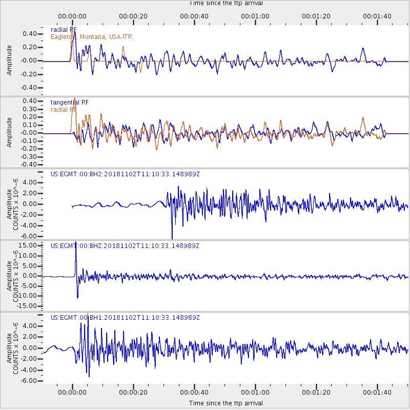
EGMT Eagleton, Montana, USA - Earthquake Result Viewer
*The percent match for this event was below the threshold and hence no stack was calculated.
| Earthquake location: |
Northwest Of Kuril Islands |
| Earthquake latitude/longitude: |
47.8/146.7 |
| Earthquake time(UTC): |
2018/11/02 (306) 11:01:15 GMT |
| Earthquake Depth: |
432 km |
| Earthquake Magnitude: |
5.9 Mww |
| Earthquake Catalog/Contributor: |
NEIC PDE/us |
|
| Network: |
US United States National Seismic Network |
| Station: |
EGMT Eagleton, Montana, USA |
| Lat/Lon: |
48.02 N/109.75 W |
| Elevation: |
1055 m |
|
| Distance: |
63.8 deg |
| Az: |
46.677 deg |
| Baz: |
313.08 deg |
| Ray Param: |
$rayparam |
*The percent match for this event was below the threshold and hence was not used in the summary stack. |
|
| Radial Match: |
74.531906 % |
| Radial Bump: |
400 |
| Transverse Match: |
66.25968 % |
| Transverse Bump: |
400 |
| SOD ConfigId: |
3131071 |
| Insert Time: |
2018-11-16 11:15:56.216 +0000 |
| GWidth: |
2.5 |
| Max Bumps: |
400 |
| Tol: |
0.001 |
|
Signal To Noise
| Channel | StoN | STA | LTA |
| US:EGMT:00:BHZ:20181102T11:10:33.148989Z | 30.783043 | 4.616285E-6 | 1.4996195E-7 |
| US:EGMT:00:BH1:20181102T11:10:33.148989Z | 6.3451095 | 1.9227803E-6 | 3.0303343E-7 |
| US:EGMT:00:BH2:20181102T11:10:33.148989Z | 7.2703824 | 1.7272002E-6 | 2.3756662E-7 |
| Arrivals |
| Ps | |
| PpPs | |
| PsPs/PpSs | |


