You are here: Home > Network List > US - United States National Seismic Network Stations List
> Station ELK Elko, Nevada, USA > Earthquake Result Viewer
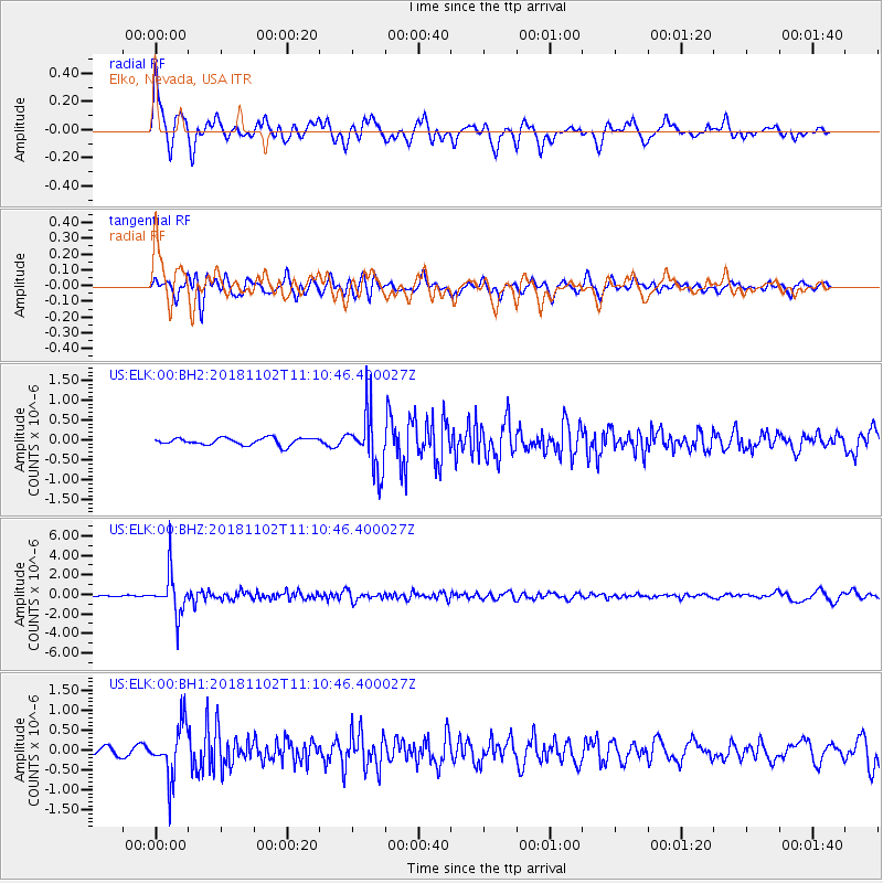
ELK Elko, Nevada, USA - Earthquake Result Viewer
*The percent match for this event was below the threshold and hence no stack was calculated.
| Earthquake location: |
Northwest Of Kuril Islands |
| Earthquake latitude/longitude: |
47.8/146.7 |
| Earthquake time(UTC): |
2018/11/02 (306) 11:01:15 GMT |
| Earthquake Depth: |
432 km |
| Earthquake Magnitude: |
5.9 Mww |
| Earthquake Catalog/Contributor: |
NEIC PDE/us |
|
| Network: |
US United States National Seismic Network |
| Station: |
ELK Elko, Nevada, USA |
| Lat/Lon: |
40.74 N/115.24 W |
| Elevation: |
2210 m |
|
| Distance: |
65.9 deg |
| Az: |
55.516 deg |
| Baz: |
313.013 deg |
| Ray Param: |
$rayparam |
*The percent match for this event was below the threshold and hence was not used in the summary stack. |
|
| Radial Match: |
78.61308 % |
| Radial Bump: |
400 |
| Transverse Match: |
76.402466 % |
| Transverse Bump: |
400 |
| SOD ConfigId: |
3131071 |
| Insert Time: |
2018-11-16 11:15:57.834 +0000 |
| GWidth: |
2.5 |
| Max Bumps: |
400 |
| Tol: |
0.001 |
|
Signal To Noise
| Channel | StoN | STA | LTA |
| US:ELK:00:BHZ:20181102T11:10:46.400027Z | 23.437754 | 2.1648084E-6 | 9.236416E-8 |
| US:ELK:00:BH1:20181102T11:10:46.400027Z | 7.4887505 | 6.637736E-7 | 8.86361E-8 |
| US:ELK:00:BH2:20181102T11:10:46.400027Z | 8.073161 | 7.167718E-7 | 8.878453E-8 |
| Arrivals |
| Ps | |
| PpPs | |
| PsPs/PpSs | |


