You are here: Home > Network List > AV - Alaska Volcano Observatory Stations List
> Station SPCN Ckakachatna North Broadband, Mount Spurr, Alaska > Earthquake Result Viewer
SPCN Ckakachatna North Broadband, Mount Spurr, Alaska - Earthquake Result Viewer
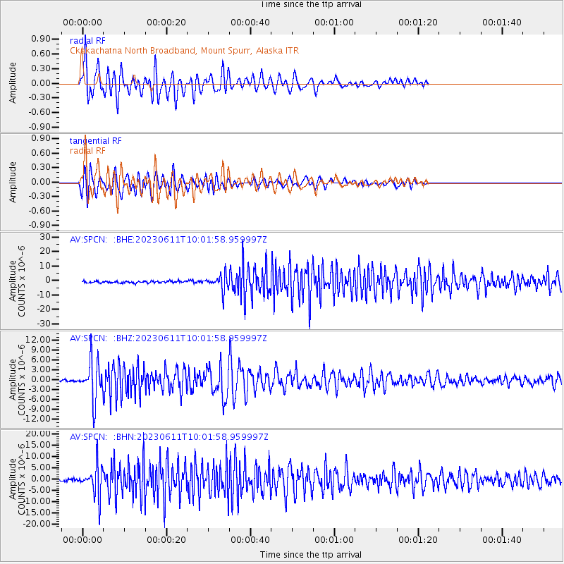
| Earthquake location: |
Hokkaido, Japan Region |
| Earthquake latitude/longitude: |
42.5/141.9 |
| Earthquake time(UTC): |
2023/06/11 (162) 09:54:45 GMT |
| Earthquake Depth: |
125 km |
| Earthquake Magnitude: |
6.2 mww |
| Earthquake Catalog/Contributor: |
NEIC PDE/us |
|
| Network: |
AV Alaska Volcano Observatory |
| Station: |
SPCN Ckakachatna North Broadband, Mount Spurr, Alaska |
| Lat/Lon: |
61.22 N/152.19 W |
| Elevation: |
735 m |
|
| Distance: |
42.6 deg |
| Az: |
40.683 deg |
| Baz: |
275.213 deg |
| Ray Param: |
0.072600484 |
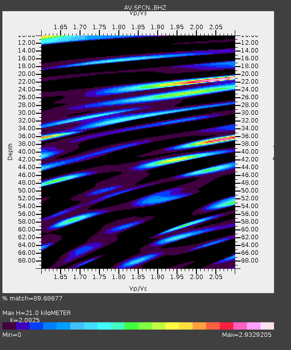
| Estimated Moho Depth: |
21.0 km |
| Estimated Crust Vp/Vs: |
2.08 |
| Assumed Crust Vp: |
6.566 km/s |
| Estimated Crust Vs: |
3.153 km/s |
| Estimated Crust Poisson's Ratio: |
0.35 |
|
| Radial Match: |
89.68677 % |
| Radial Bump: |
400 |
| Transverse Match: |
89.44855 % |
| Transverse Bump: |
400 |
| SOD ConfigId: |
30536071 |
| Insert Time: |
2023-06-25 10:05:14.814 +0000 |
| GWidth: |
2.5 |
| Max Bumps: |
400 |
| Tol: |
0.001 |
|
Signal To Noise
| Channel | StoN | STA | LTA |
| AV:SPCN: :BHZ:20230611T10:01:58.959997Z | 25.656147 | 6.04288E-6 | 2.3553342E-7 |
| AV:SPCN: :BHN:20230611T10:01:58.959997Z | 16.236418 | 6.7906517E-6 | 4.1823583E-7 |
| AV:SPCN: :BHE:20230611T10:01:58.959997Z | 8.986536 | 5.261218E-6 | 5.8545567E-7 |
| Arrivals |
| Ps | 3.7 SECOND |
| PpPs | 9.3 SECOND |
| PsPs/PpSs | 13 SECOND |


