You are here: Home > Network List > AV - Alaska Volcano Observatory Stations List
> Station SPCR Ckakachatna River, Mount Spurr, Alaska > Earthquake Result Viewer
SPCR Ckakachatna River, Mount Spurr, Alaska - Earthquake Result Viewer
| Earthquake location: |
Hokkaido, Japan Region |
| Earthquake latitude/longitude: |
42.5/141.9 |
| Earthquake time(UTC): |
2023/06/11 (162) 09:54:45 GMT |
| Earthquake Depth: |
125 km |
| Earthquake Magnitude: |
6.2 mww |
| Earthquake Catalog/Contributor: |
NEIC PDE/us |
|
| Network: |
AV Alaska Volcano Observatory |
| Station: |
SPCR Ckakachatna River, Mount Spurr, Alaska |
| Lat/Lon: |
61.20 N/152.21 W |
| Elevation: |
984 m |
|
| Distance: |
42.6 deg |
| Az: |
40.72 deg |
| Baz: |
275.22 deg |
| Ray Param: |
0.07260642 |
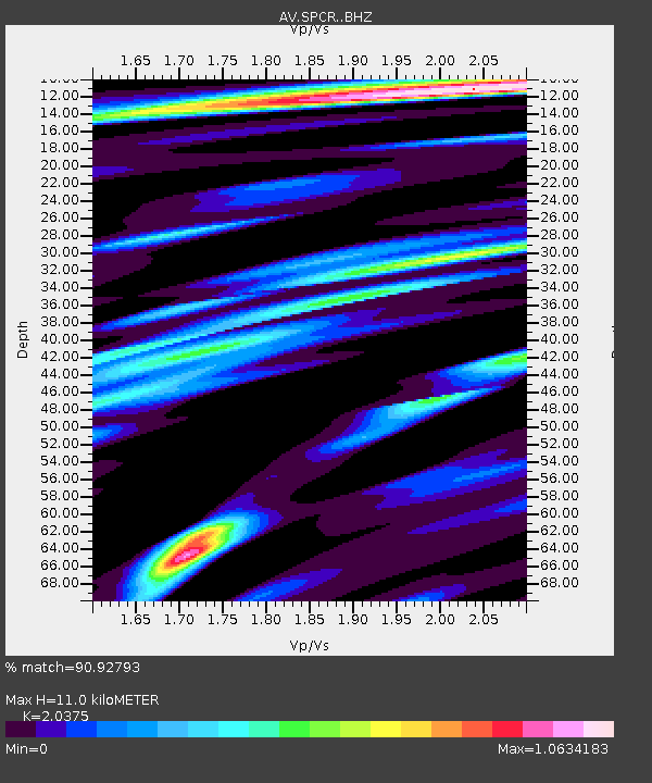
| Estimated Moho Depth: |
11.0 km |
| Estimated Crust Vp/Vs: |
2.04 |
| Assumed Crust Vp: |
6.566 km/s |
| Estimated Crust Vs: |
3.223 km/s |
| Estimated Crust Poisson's Ratio: |
0.34 |
|
| Radial Match: |
90.92793 % |
| Radial Bump: |
400 |
| Transverse Match: |
86.198 % |
| Transverse Bump: |
400 |
| SOD ConfigId: |
30536071 |
| Insert Time: |
2023-06-25 10:05:18.463 +0000 |
| GWidth: |
2.5 |
| Max Bumps: |
400 |
| Tol: |
0.001 |
|
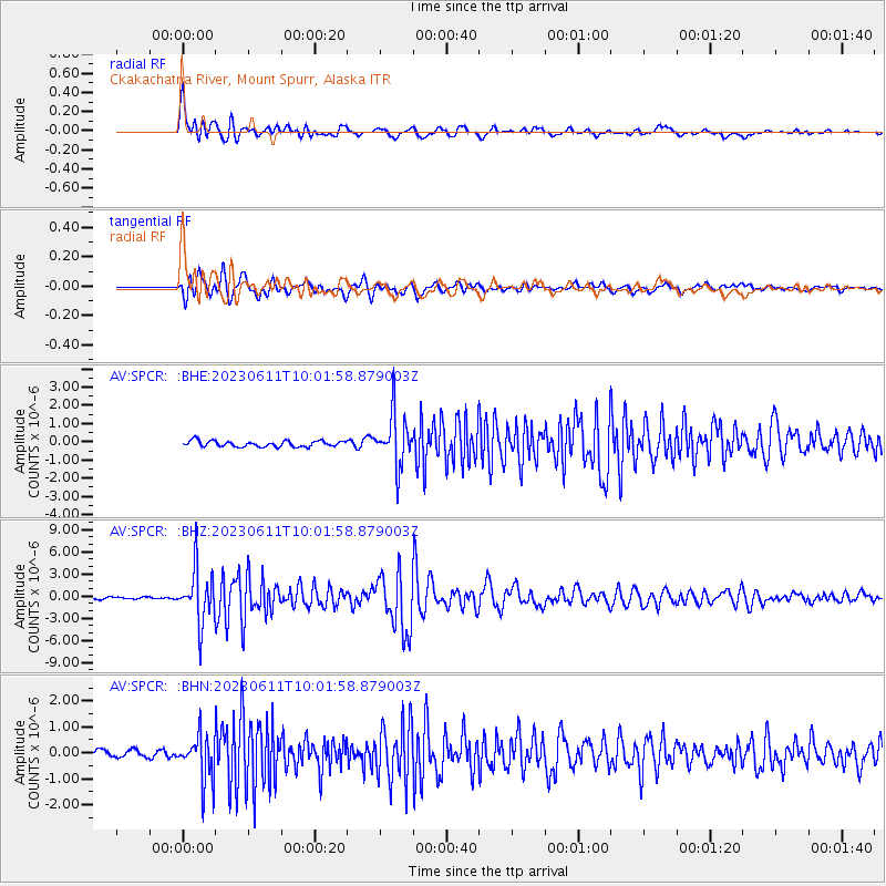
Signal To Noise
| Channel | StoN | STA | LTA |
| AV:SPCR: :BHZ:20230611T10:01:58.879003Z | 29.026842 | 3.7361478E-6 | 1.2871355E-7 |
| AV:SPCR: :BHN:20230611T10:01:58.879003Z | 6.1303186 | 9.0156624E-7 | 1.4706679E-7 |
| AV:SPCR: :BHE:20230611T10:01:58.879003Z | 8.7837305 | 1.41133E-6 | 1.6067547E-7 |
| Arrivals |
| Ps | 1.8 SECOND |
| PpPs | 4.8 SECOND |
| PsPs/PpSs | 6.6 SECOND |


