You are here: Home > Network List > CI - Caltech Regional Seismic Network Stations List
> Station SWS Sam W. Stewart, Westmorland, CA, USA > Earthquake Result Viewer
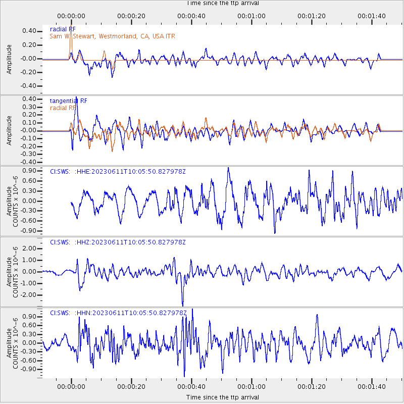
SWS Sam W. Stewart, Westmorland, CA, USA - Earthquake Result Viewer
*The percent match for this event was below the threshold and hence no stack was calculated.
| Earthquake location: |
Hokkaido, Japan Region |
| Earthquake latitude/longitude: |
42.5/141.9 |
| Earthquake time(UTC): |
2023/06/11 (162) 09:54:45 GMT |
| Earthquake Depth: |
125 km |
| Earthquake Magnitude: |
6.2 mww |
| Earthquake Catalog/Contributor: |
NEIC PDE/us |
|
| Network: |
CI Caltech Regional Seismic Network |
| Station: |
SWS Sam W. Stewart, Westmorland, CA, USA |
| Lat/Lon: |
32.94 N/115.80 W |
| Elevation: |
140 m |
|
| Distance: |
76.6 deg |
| Az: |
57.65 deg |
| Baz: |
312.044 deg |
| Ray Param: |
$rayparam |
*The percent match for this event was below the threshold and hence was not used in the summary stack. |
|
| Radial Match: |
62.218212 % |
| Radial Bump: |
400 |
| Transverse Match: |
63.114998 % |
| Transverse Bump: |
400 |
| SOD ConfigId: |
30536071 |
| Insert Time: |
2023-06-25 10:11:04.385 +0000 |
| GWidth: |
2.5 |
| Max Bumps: |
400 |
| Tol: |
0.001 |
|
Signal To Noise
| Channel | StoN | STA | LTA |
| CI:SWS: :HHZ:20230611T10:05:50.827978Z | 3.6615348 | 7.1658496E-7 | 1.9570618E-7 |
| CI:SWS: :HHN:20230611T10:05:50.827978Z | 2.2256918 | 3.7397356E-7 | 1.6802576E-7 |
| CI:SWS: :HHE:20230611T10:05:50.827978Z | 0.9378606 | 2.537553E-7 | 2.7056825E-7 |
| Arrivals |
| Ps | |
| PpPs | |
| PsPs/PpSs | |


