You are here: Home > Network List > CN - Canadian National Seismograph Network Stations List
> Station DI2B Dawson Inlet, BC, CA > Earthquake Result Viewer
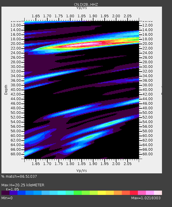
DI2B Dawson Inlet, BC, CA - Earthquake Result Viewer
| Earthquake location: |
Hokkaido, Japan Region |
| Earthquake latitude/longitude: |
42.5/141.9 |
| Earthquake time(UTC): |
2023/06/11 (162) 09:54:45 GMT |
| Earthquake Depth: |
125 km |
| Earthquake Magnitude: |
6.2 mww |
| Earthquake Catalog/Contributor: |
NEIC PDE/us |
|
| Network: |
CN Canadian National Seismograph Network |
| Station: |
DI2B Dawson Inlet, BC, CA |
| Lat/Lon: |
53.20 N/132.48 W |
| Elevation: |
82 m |
|
| Distance: |
55.1 deg |
| Az: |
46.998 deg |
| Baz: |
296.019 deg |
| Ray Param: |
0.06462313 |
| Estimated Moho Depth: |
20.25 km |
| Estimated Crust Vp/Vs: |
1.85 |
| Assumed Crust Vp: |
6.183 km/s |
| Estimated Crust Vs: |
3.342 km/s |
| Estimated Crust Poisson's Ratio: |
0.29 |
|
| Radial Match: |
86.51037 % |
| Radial Bump: |
400 |
| Transverse Match: |
52.823753 % |
| Transverse Bump: |
400 |
| SOD ConfigId: |
30536071 |
| Insert Time: |
2023-06-25 10:12:09.538 +0000 |
| GWidth: |
2.5 |
| Max Bumps: |
400 |
| Tol: |
0.001 |
|

Signal To Noise
| Channel | StoN | STA | LTA |
| CN:DI2B: :HHZ:20230611T10:03:33.730017Z | 7.197054 | 1.1508366E-6 | 1.5990383E-7 |
| CN:DI2B: :HHN:20230611T10:03:33.730017Z | 2.1170056 | 3.0090717E-7 | 1.421381E-7 |
| CN:DI2B: :HHE:20230611T10:03:33.730017Z | 3.6100903 | 4.9813775E-7 | 1.3798486E-7 |
| Arrivals |
| Ps | 2.9 SECOND |
| PpPs | 8.9 SECOND |
| PsPs/PpSs | 12 SECOND |


