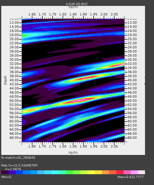
SUR Sutherland, South Africa - Earthquake Result Viewer
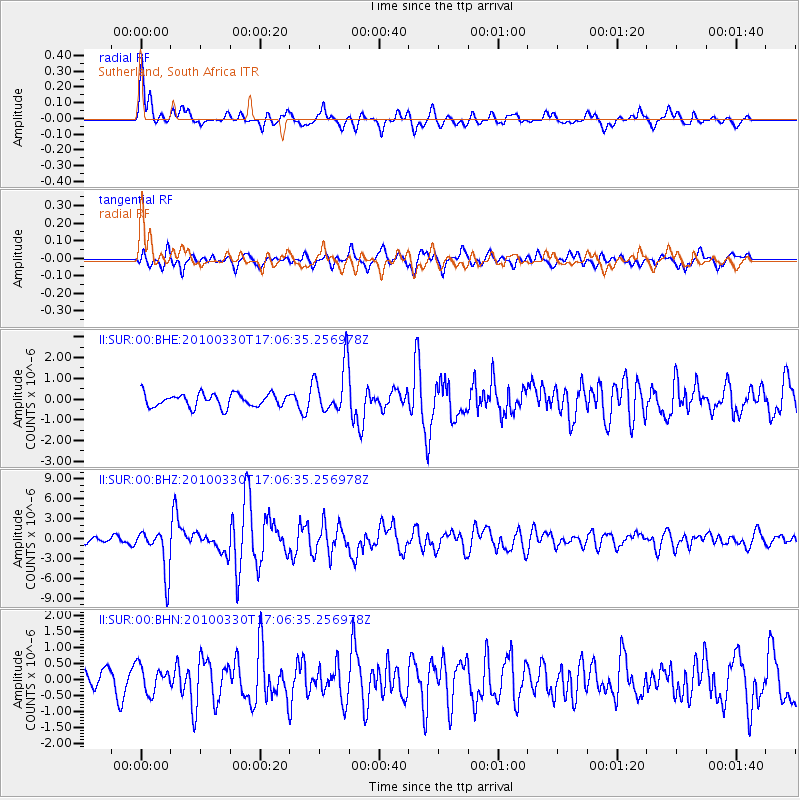
Earthquake location: Andaman Islands, India Region
Earthquake latitude/longitude: 13.7/92.8
Earthquake time(UTC): 2010/03/30 (089) 16:54:46 GMT
Earthquake Depth: 34 km
Earthquake Magnitude: 6.5 MB, 6.3 MS, 6.7 MW, 6.6 MW
Earthquake Catalog/Contributor: WHDF/NEIC
Network: II Global Seismograph Network (GSN - IRIS/IDA)
Station: SUR Sutherland, South Africa
Lat/Lon: 32.38 S/20.81 E
Elevation: 1770 m
Distance: 82.6 deg
Az: 234.25 deg
Baz: 68.802 deg
Ray Param: 0.046727877
Estimated Moho Depth: 32.0 km
Estimated Crust Vp/Vs: 2.10
Assumed Crust Vp: 6.51 km/s
Estimated Crust Vs: 3.104 km/s
Estimated Crust Poisson's Ratio: 0.35
Radial Match: 81.295845 %
Radial Bump: 400
Transverse Match: 74.72387 %
Transverse Bump: 400
SOD ConfigId: 312771
Insert Time: 2010-06-28 18:08:06.337 +0000
GWidth: 2.5
Max Bumps: 400
Tol: 0.001

Signal To Noise

ChannelStoNSTALTA
II:SUR:00:BHZ:20100330T17:06:35.256978Z9.3714063.3603048E-63.5857E-7
II:SUR:00:BHN:20100330T17:06:35.256978Z0.99091344.1308914E-74.1687713E-7
II:SUR:00:BHE:20100330T17:06:35.256978Z3.74229961.19047E-63.1811192E-7
Arrivals
Ps5.5 SECOND
PpPs15 SECOND
PsPs/PpSs20 SECOND