You are here: Home > Network List > IW - Intermountain West Stations List
> Station MOOW Moose Ponds, Wyoming, USA > Earthquake Result Viewer
MOOW Moose Ponds, Wyoming, USA - Earthquake Result Viewer
| Earthquake location: |
Hokkaido, Japan Region |
| Earthquake latitude/longitude: |
42.5/141.9 |
| Earthquake time(UTC): |
2023/06/11 (162) 09:54:45 GMT |
| Earthquake Depth: |
125 km |
| Earthquake Magnitude: |
6.2 mww |
| Earthquake Catalog/Contributor: |
NEIC PDE/us |
|
| Network: |
IW Intermountain West |
| Station: |
MOOW Moose Ponds, Wyoming, USA |
| Lat/Lon: |
43.75 N/110.74 W |
| Elevation: |
2128 m |
|
| Distance: |
72.3 deg |
| Az: |
46.579 deg |
| Baz: |
312.195 deg |
| Ray Param: |
0.053469595 |
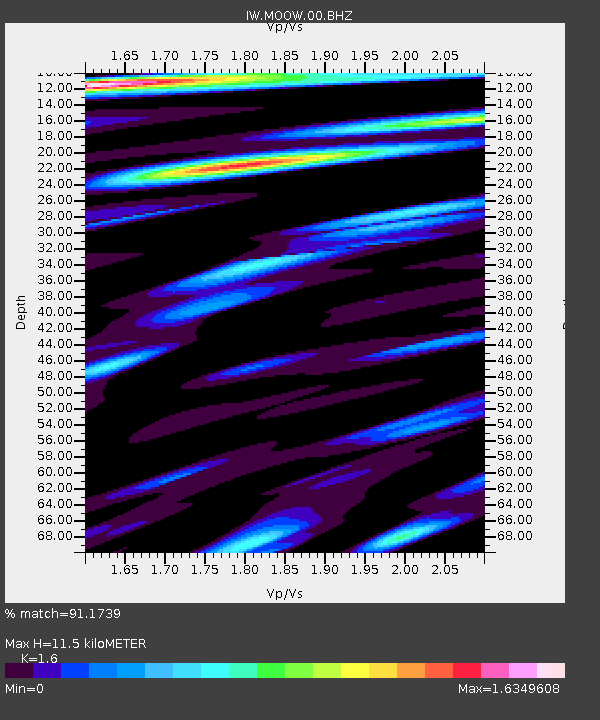
| Estimated Moho Depth: |
11.5 km |
| Estimated Crust Vp/Vs: |
1.60 |
| Assumed Crust Vp: |
6.207 km/s |
| Estimated Crust Vs: |
3.879 km/s |
| Estimated Crust Poisson's Ratio: |
0.18 |
|
| Radial Match: |
91.1739 % |
| Radial Bump: |
400 |
| Transverse Match: |
91.56516 % |
| Transverse Bump: |
400 |
| SOD ConfigId: |
30536071 |
| Insert Time: |
2023-06-25 10:20:09.574 +0000 |
| GWidth: |
2.5 |
| Max Bumps: |
400 |
| Tol: |
0.001 |
|

Signal To Noise
| Channel | StoN | STA | LTA |
| IW:MOOW:00:BHZ:20230611T10:05:26.100012Z | 19.617842 | 1.0673936E-6 | 5.4409323E-8 |
| IW:MOOW:00:BH1:20230611T10:05:26.100012Z | 5.535074 | 2.8108994E-7 | 5.078341E-8 |
| IW:MOOW:00:BH2:20230611T10:05:26.100012Z | 2.925647 | 1.842E-7 | 6.296043E-8 |
| Arrivals |
| Ps | 1.2 SECOND |
| PpPs | 4.6 SECOND |
| PsPs/PpSs | 5.8 SECOND |


