You are here: Home > Network List > N4 - Central and EAstern US Network Stations List
> Station J47A Sunmer, MI, USA > Earthquake Result Viewer
J47A Sunmer, MI, USA - Earthquake Result Viewer
| Earthquake location: |
Hokkaido, Japan Region |
| Earthquake latitude/longitude: |
42.5/141.9 |
| Earthquake time(UTC): |
2023/06/11 (162) 09:54:45 GMT |
| Earthquake Depth: |
125 km |
| Earthquake Magnitude: |
6.2 mww |
| Earthquake Catalog/Contributor: |
NEIC PDE/us |
|
| Network: |
N4 Central and EAstern US Network |
| Station: |
J47A Sunmer, MI, USA |
| Lat/Lon: |
43.24 N/84.82 W |
| Elevation: |
236 m |
|
| Distance: |
84.9 deg |
| Az: |
32.307 deg |
| Baz: |
327.275 deg |
| Ray Param: |
0.04490132 |
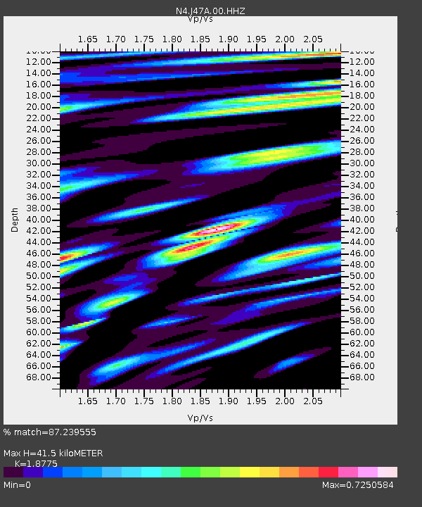
| Estimated Moho Depth: |
41.5 km |
| Estimated Crust Vp/Vs: |
1.88 |
| Assumed Crust Vp: |
6.483 km/s |
| Estimated Crust Vs: |
3.453 km/s |
| Estimated Crust Poisson's Ratio: |
0.30 |
|
| Radial Match: |
87.239555 % |
| Radial Bump: |
400 |
| Transverse Match: |
76.79965 % |
| Transverse Bump: |
400 |
| SOD ConfigId: |
30536071 |
| Insert Time: |
2023-06-25 10:23:14.605 +0000 |
| GWidth: |
2.5 |
| Max Bumps: |
400 |
| Tol: |
0.001 |
|

Signal To Noise
| Channel | StoN | STA | LTA |
| N4:J47A:00:HHZ:20230611T10:06:34.819982Z | 18.741535 | 2.290345E-6 | 1.2220691E-7 |
| N4:J47A:00:HH1:20230611T10:06:34.819982Z | 6.188894 | 9.3230454E-7 | 1.5064154E-7 |
| N4:J47A:00:HH2:20230611T10:06:34.819982Z | 7.216855 | 1.1032724E-6 | 1.528744E-7 |
| Arrivals |
| Ps | 5.7 SECOND |
| PpPs | 18 SECOND |
| PsPs/PpSs | 24 SECOND |


