You are here: Home > Network List > TM - Thai Seismic Monitoring Network Stations List
> Station PANO PANO staion > Earthquake Result Viewer
PANO PANO staion - Earthquake Result Viewer
| Earthquake location: |
Hokkaido, Japan Region |
| Earthquake latitude/longitude: |
42.5/141.9 |
| Earthquake time(UTC): |
2023/06/11 (162) 09:54:45 GMT |
| Earthquake Depth: |
125 km |
| Earthquake Magnitude: |
6.2 mww |
| Earthquake Catalog/Contributor: |
NEIC PDE/us |
|
| Network: |
TM Thai Seismic Monitoring Network |
| Station: |
PANO PANO staion |
| Lat/Lon: |
17.15 N/104.61 E |
| Elevation: |
136 m |
|
| Distance: |
40.6 deg |
| Az: |
242.989 deg |
| Baz: |
43.536 deg |
| Ray Param: |
0.0738658 |
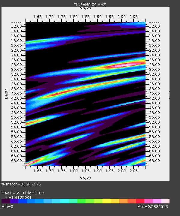
| Estimated Moho Depth: |
69.0 km |
| Estimated Crust Vp/Vs: |
1.61 |
| Assumed Crust Vp: |
6.498 km/s |
| Estimated Crust Vs: |
4.029 km/s |
| Estimated Crust Poisson's Ratio: |
0.19 |
|
| Radial Match: |
83.937996 % |
| Radial Bump: |
400 |
| Transverse Match: |
81.62836 % |
| Transverse Bump: |
400 |
| SOD ConfigId: |
30536071 |
| Insert Time: |
2023-06-25 10:35:14.587 +0000 |
| GWidth: |
2.5 |
| Max Bumps: |
400 |
| Tol: |
0.001 |
|

Signal To Noise
| Channel | StoN | STA | LTA |
| TM:PANO:00:HHZ:20230611T10:01:42.174993Z | 23.14974 | 4.773871E-7 | 2.0621705E-8 |
| TM:PANO:00:HHN:20230611T10:01:42.174993Z | 6.335773 | 1.3265542E-7 | 2.0937527E-8 |
| TM:PANO:00:HHE:20230611T10:01:42.174993Z | 1.3428388 | 2.6906562E-8 | 2.0037076E-8 |
| Arrivals |
| Ps | 7.0 SECOND |
| PpPs | 26 SECOND |
| PsPs/PpSs | 33 SECOND |


