TNA Tin City Broadband - Earthquake Result Viewer
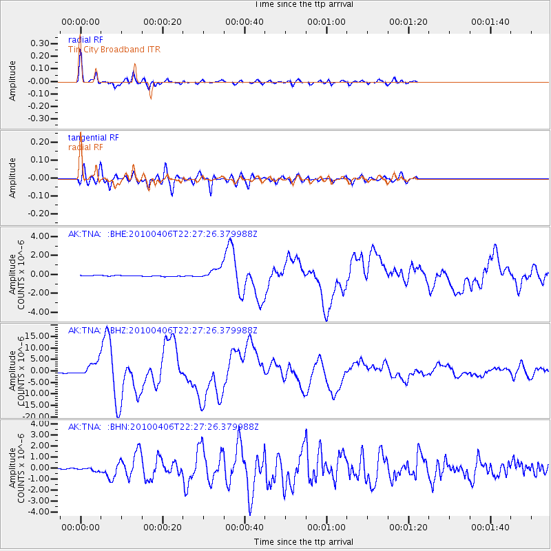
Earthquake location: Northern Sumatra, Indonesia
Earthquake latitude/longitude: 2.4/97.0
Earthquake time(UTC): 2010/04/06 (096) 22:15:01 GMT
Earthquake Depth: 31 km
Earthquake Magnitude: 7.0 MB, 7.9 MS, 7.8 MW, 7.7 MW
Earthquake Catalog/Contributor: WHDF/NEIC
Network: AK Alaska Regional Network
Station: TNA Tin City Broadband
Lat/Lon: 65.56 N/167.92 W
Elevation: 74 m
Distance: 89.9 deg
Az: 24.484 deg
Baz: 275.556 deg
Ray Param: 0.041705605
Estimated Moho Depth: 29.75 km
Estimated Crust Vp/Vs: 1.81
Assumed Crust Vp: 6.307 km/s
Estimated Crust Vs: 3.489 km/s
Estimated Crust Poisson's Ratio: 0.28
Radial Match: 96.13618 %
Radial Bump: 398
Transverse Match: 93.18313 %
Transverse Bump: 400
SOD ConfigId: 314316
Insert Time: 2010-07-27 06:34:18.319 +0000
GWidth: 2.5
Max Bumps: 400
Tol: 0.001

Signal To Noise

ChannelStoNSTALTA
AK:TNA: :BHZ:20100406T22:27:26.379988Z18.6200623.3760011E-61.8130989E-7
AK:TNA: :BHN:20100406T22:27:26.379988Z1.7275611.4590334E-78.445626E-8
AK:TNA: :BHE:20100406T22:27:26.379988Z14.3681996.3701646E-74.4335163E-8
Arrivals
Ps3.9 SECOND
PpPs13 SECOND
PsPs/PpSs17 SECOND