You are here: Home > Network List > TX - Texas Seismological Network Stations List
> Station PB28 Culberson South > Earthquake Result Viewer
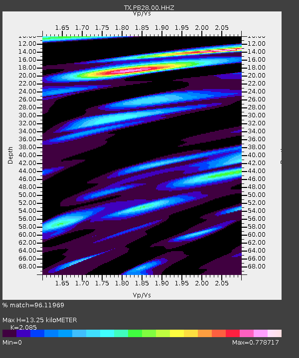
PB28 Culberson South - Earthquake Result Viewer
| Earthquake location: |
Hokkaido, Japan Region |
| Earthquake latitude/longitude: |
42.5/141.9 |
| Earthquake time(UTC): |
2023/06/11 (162) 09:54:45 GMT |
| Earthquake Depth: |
125 km |
| Earthquake Magnitude: |
6.2 mww |
| Earthquake Catalog/Contributor: |
NEIC PDE/us |
|
| Network: |
TX Texas Seismological Network |
| Station: |
PB28 Culberson South |
| Lat/Lon: |
31.67 N/104.50 W |
| Elevation: |
1204 m |
|
| Distance: |
84.3 deg |
| Az: |
51.764 deg |
| Baz: |
317.082 deg |
| Ray Param: |
0.04532622 |
| Estimated Moho Depth: |
13.25 km |
| Estimated Crust Vp/Vs: |
2.09 |
| Assumed Crust Vp: |
6.361 km/s |
| Estimated Crust Vs: |
3.051 km/s |
| Estimated Crust Poisson's Ratio: |
0.35 |
|
| Radial Match: |
96.11969 % |
| Radial Bump: |
293 |
| Transverse Match: |
88.28809 % |
| Transverse Bump: |
400 |
| SOD ConfigId: |
30536071 |
| Insert Time: |
2023-06-25 10:36:34.715 +0000 |
| GWidth: |
2.5 |
| Max Bumps: |
400 |
| Tol: |
0.001 |
|

Signal To Noise
| Channel | StoN | STA | LTA |
| TX:PB28:00:HHZ:20230611T10:06:31.860021Z | 30.412415 | 1.1290056E-6 | 3.712318E-8 |
| TX:PB28:00:HH1:20230611T10:06:31.860021Z | 6.5340424 | 1.9663366E-7 | 3.0093723E-8 |
| TX:PB28:00:HH2:20230611T10:06:31.860021Z | 7.183075 | 2.4167826E-7 | 3.3645517E-8 |
| Arrivals |
| Ps | 2.3 SECOND |
| PpPs | 6.3 SECOND |
| PsPs/PpSs | 8.6 SECOND |


