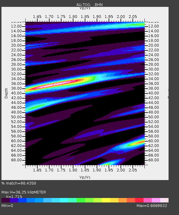
TOO Toolangi, Victoria - Earthquake Result Viewer

Earthquake location: Northern Sumatra, Indonesia
Earthquake latitude/longitude: 2.4/97.0
Earthquake time(UTC): 2010/04/06 (096) 22:15:01 GMT
Earthquake Depth: 31 km
Earthquake Magnitude: 7.0 MB, 7.9 MS, 7.8 MW, 7.7 MW
Earthquake Catalog/Contributor: WHDF/NEIC
Network: AU Australian Seismological Centre
Station: TOO Toolangi, Victoria
Lat/Lon: 37.57 S/145.49 E
Elevation: 604 m
Distance: 59.9 deg
Az: 136.586 deg
Baz: 300.206 deg
Ray Param: 0.06183653
Estimated Moho Depth: 36.25 km
Estimated Crust Vp/Vs: 1.72
Assumed Crust Vp: 6.577 km/s
Estimated Crust Vs: 3.835 km/s
Estimated Crust Poisson's Ratio: 0.24
Radial Match: 98.4358 %
Radial Bump: 293
Transverse Match: 87.64998 %
Transverse Bump: 400
SOD ConfigId: 314316
Insert Time: 2010-07-27 06:35:04.475 +0000
GWidth: 2.5
Max Bumps: 400
Tol: 0.001

Signal To Noise

ChannelStoNSTALTA
AU:TOO: :BHZ:20100406T22:24:33.645002Z6.48853641.9473193E-63.0011688E-7
AU:TOO: :BHN:20100406T22:24:33.645002Z1.78066034.5784773E-72.5712245E-7
AU:TOO: :BHE:20100406T22:24:33.645002Z2.7696047.3029287E-72.6368133E-7
Arrivals
Ps4.1 SECOND
PpPs14 SECOND
PsPs/PpSs18 SECOND