You are here: Home > Network List > US - United States National Seismic Network Stations List
> Station AGMN Agassiz National Wildlife Refuge, Minnesota, USA > Earthquake Result Viewer
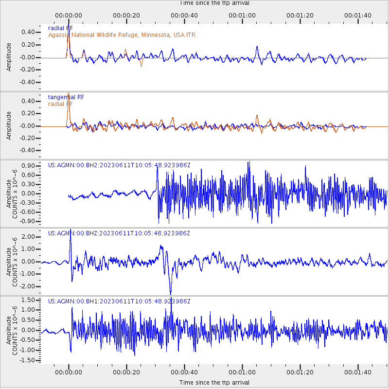
AGMN Agassiz National Wildlife Refuge, Minnesota, USA - Earthquake Result Viewer
*The percent match for this event was below the threshold and hence no stack was calculated.
| Earthquake location: |
Hokkaido, Japan Region |
| Earthquake latitude/longitude: |
42.5/141.9 |
| Earthquake time(UTC): |
2023/06/11 (162) 09:54:45 GMT |
| Earthquake Depth: |
125 km |
| Earthquake Magnitude: |
6.2 mww |
| Earthquake Catalog/Contributor: |
NEIC PDE/us |
|
| Network: |
US United States National Seismic Network |
| Station: |
AGMN Agassiz National Wildlife Refuge, Minnesota, USA |
| Lat/Lon: |
48.30 N/95.86 W |
| Elevation: |
351 m |
|
| Distance: |
76.2 deg |
| Az: |
35.574 deg |
| Baz: |
319.909 deg |
| Ray Param: |
$rayparam |
*The percent match for this event was below the threshold and hence was not used in the summary stack. |
|
| Radial Match: |
75.121346 % |
| Radial Bump: |
400 |
| Transverse Match: |
65.6532 % |
| Transverse Bump: |
400 |
| SOD ConfigId: |
30536071 |
| Insert Time: |
2023-06-25 10:38:53.099 +0000 |
| GWidth: |
2.5 |
| Max Bumps: |
400 |
| Tol: |
0.001 |
|
Signal To Noise
| Channel | StoN | STA | LTA |
| US:AGMN:00:BHZ:20230611T10:05:48.923986Z | 12.684094 | 8.087621E-7 | 6.376191E-8 |
| US:AGMN:00:BH1:20230611T10:05:48.923986Z | 3.9772277 | 4.4904831E-7 | 1.1290486E-7 |
| US:AGMN:00:BH2:20230611T10:05:48.923986Z | 5.908856 | 4.1885343E-7 | 7.0885704E-8 |
| Arrivals |
| Ps | |
| PpPs | |
| PsPs/PpSs | |


