You are here: Home > Network List > UW - Pacific Northwest Regional Seismic Network Stations List
> Station BDGR Fisse-Smith Property, Kittitas, WA, USA > Earthquake Result Viewer
BDGR Fisse-Smith Property, Kittitas, WA, USA - Earthquake Result Viewer
| Earthquake location: |
Hokkaido, Japan Region |
| Earthquake latitude/longitude: |
42.5/141.9 |
| Earthquake time(UTC): |
2023/06/11 (162) 09:54:45 GMT |
| Earthquake Depth: |
125 km |
| Earthquake Magnitude: |
6.2 mww |
| Earthquake Catalog/Contributor: |
NEIC PDE/us |
|
| Network: |
UW Pacific Northwest Regional Seismic Network |
| Station: |
BDGR Fisse-Smith Property, Kittitas, WA, USA |
| Lat/Lon: |
46.86 N/120.30 W |
| Elevation: |
642 m |
|
| Distance: |
65.1 deg |
| Az: |
48.566 deg |
| Baz: |
306.141 deg |
| Ray Param: |
0.058149606 |
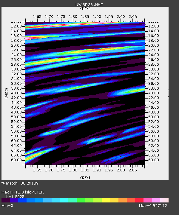
| Estimated Moho Depth: |
11.0 km |
| Estimated Crust Vp/Vs: |
1.80 |
| Assumed Crust Vp: |
6.597 km/s |
| Estimated Crust Vs: |
3.66 km/s |
| Estimated Crust Poisson's Ratio: |
0.28 |
|
| Radial Match: |
88.29139 % |
| Radial Bump: |
400 |
| Transverse Match: |
77.43985 % |
| Transverse Bump: |
400 |
| SOD ConfigId: |
30536071 |
| Insert Time: |
2023-06-25 10:41:04.917 +0000 |
| GWidth: |
2.5 |
| Max Bumps: |
400 |
| Tol: |
0.001 |
|

Signal To Noise
| Channel | StoN | STA | LTA |
| UW:BDGR: :HHZ:20230611T10:04:41.670019Z | 17.688908 | 1.381827E-6 | 7.8118276E-8 |
| UW:BDGR: :HHN:20230611T10:04:41.670019Z | 4.901318 | 4.2101277E-7 | 8.5897874E-8 |
| UW:BDGR: :HHE:20230611T10:04:41.670019Z | 7.3245673 | 5.8538484E-7 | 7.992074E-8 |
| Arrivals |
| Ps | 1.4 SECOND |
| PpPs | 4.5 SECOND |
| PsPs/PpSs | 5.9 SECOND |


