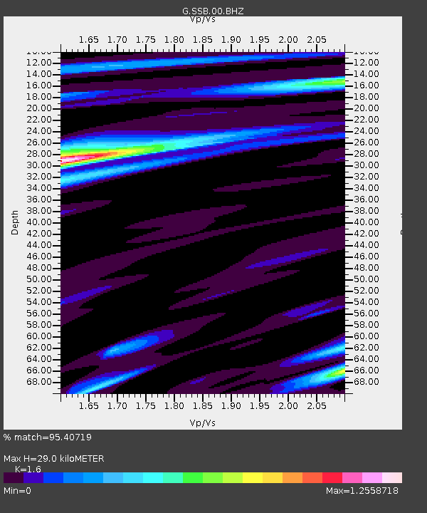
SSB Saint Sauveur Badole, France - Earthquake Result Viewer

Earthquake location: Northern Sumatra, Indonesia
Earthquake latitude/longitude: 2.4/97.0
Earthquake time(UTC): 2010/04/06 (096) 22:15:01 GMT
Earthquake Depth: 31 km
Earthquake Magnitude: 7.0 MB, 7.9 MS, 7.8 MW, 7.7 MW
Earthquake Catalog/Contributor: WHDF/NEIC
Network: G GEOSCOPE
Station: SSB Saint Sauveur Badole, France
Lat/Lon: 45.28 N/4.54 E
Elevation: 700 m
Distance: 90.1 deg
Az: 315.141 deg
Baz: 86.555 deg
Ray Param: 0.04169448
Estimated Moho Depth: 29.0 km
Estimated Crust Vp/Vs: 1.60
Assumed Crust Vp: 6.1 km/s
Estimated Crust Vs: 3.812 km/s
Estimated Crust Poisson's Ratio: 0.18
Radial Match: 95.40719 %
Radial Bump: 316
Transverse Match: 82.16446 %
Transverse Bump: 400
SOD ConfigId: 314316
Insert Time: 2010-07-27 06:36:57.475 +0000
GWidth: 2.5
Max Bumps: 400
Tol: 0.001

Signal To Noise

ChannelStoNSTALTA
G:SSB:00:BHZ:20100406T22:27:27.10002Z6.9728511.9387091E-62.780368E-7
G:SSB:00:BHN:20100406T22:27:27.10002Z3.05663085.5590306E-71.8186792E-7
G:SSB:00:BHE:20100406T22:27:27.10002Z3.71563558.370387E-72.2527472E-7
Arrivals
Ps2.9 SECOND
PpPs12 SECOND
PsPs/PpSs15 SECOND