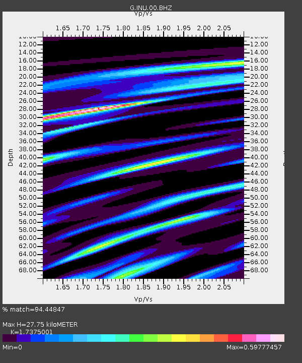
INU Inuyama, Japan - Earthquake Result Viewer
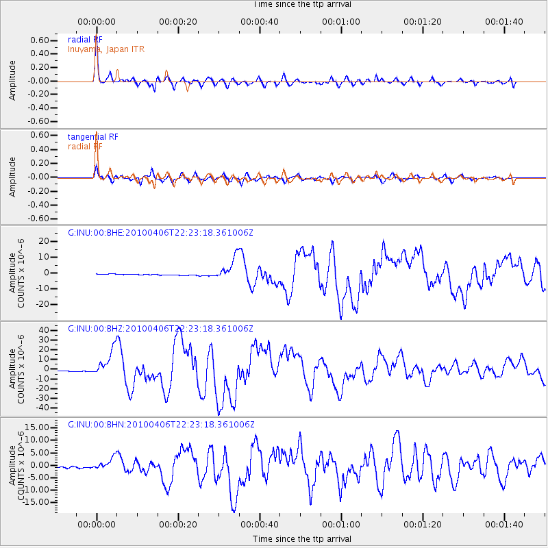
Earthquake location: Northern Sumatra, Indonesia
Earthquake latitude/longitude: 2.4/97.0
Earthquake time(UTC): 2010/04/06 (096) 22:15:01 GMT
Earthquake Depth: 31 km
Earthquake Magnitude: 7.0 MB, 7.9 MS, 7.8 MW, 7.7 MW
Earthquake Catalog/Contributor: WHDF/NEIC
Network: G GEOSCOPE
Station: INU Inuyama, Japan
Lat/Lon: 35.35 N/137.03 E
Elevation: 132 m
Distance: 49.5 deg
Az: 43.701 deg
Baz: 237.613 deg
Ray Param: 0.0686136
Estimated Moho Depth: 27.75 km
Estimated Crust Vp/Vs: 1.74
Assumed Crust Vp: 6.461 km/s
Estimated Crust Vs: 3.719 km/s
Estimated Crust Poisson's Ratio: 0.25
Radial Match: 94.44847 %
Radial Bump: 400
Transverse Match: 88.8139 %
Transverse Bump: 400
SOD ConfigId: 314316
Insert Time: 2010-07-27 06:37:01.937 +0000
GWidth: 2.5
Max Bumps: 400
Tol: 0.001

Signal To Noise

ChannelStoNSTALTA
G:INU:00:BHZ:20100406T22:23:18.361006Z28.111831.4674318E-55.2199795E-7
G:INU:00:BHN:20100406T22:23:18.361006Z10.431522.5318013E-62.4270682E-7
G:INU:00:BHE:20100406T22:23:18.361006Z20.6512057.431008E-63.598341E-7
Arrivals
Ps3.4 SECOND
PpPs11 SECOND
PsPs/PpSs14 SECOND