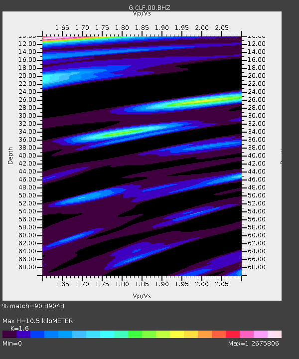
CLF Chambon la Foret observatory, France - Earthquake Result Viewer
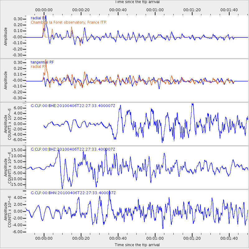
Earthquake location: Northern Sumatra, Indonesia
Earthquake latitude/longitude: 2.4/97.0
Earthquake time(UTC): 2010/04/06 (096) 22:15:01 GMT
Earthquake Depth: 31 km
Earthquake Magnitude: 7.0 MB, 7.9 MS, 7.8 MW, 7.7 MW
Earthquake Catalog/Contributor: WHDF/NEIC
Network: G GEOSCOPE
Station: CLF Chambon la Foret observatory, France
Lat/Lon: 48.03 N/2.26 E
Elevation: 145 m
Distance: 91.5 deg
Az: 317.999 deg
Baz: 84.861 deg
Ray Param: 0.041597325
Estimated Moho Depth: 10.5 km
Estimated Crust Vp/Vs: 1.60
Assumed Crust Vp: 6.12 km/s
Estimated Crust Vs: 3.825 km/s
Estimated Crust Poisson's Ratio: 0.18
Radial Match: 90.89048 %
Radial Bump: 400
Transverse Match: 53.43594 %
Transverse Bump: 400
SOD ConfigId: 314316
Insert Time: 2010-07-27 06:37:07.733 +0000
GWidth: 2.5
Max Bumps: 400
Tol: 0.001

Signal To Noise

ChannelStoNSTALTA
G:CLF:00:BHZ:20100406T22:27:33.400007Z2.09830951.7157417E-68.1767814E-7
G:CLF:00:BHN:20100406T22:27:33.400007Z1.11286141.4253434E-61.2807914E-6
G:CLF:00:BHE:20100406T22:27:33.400007Z0.776591547.3190756E-79.424614E-7
Arrivals
Ps1.1 SECOND
PpPs4.4 SECOND
PsPs/PpSs5.4 SECOND